
ဖိုင်:Asia 800ad.jpg
ဤနမူနာ၏ အရွယ်အစား - ၈၀၀ × ၄၆၃ ပစ်ဇယ်။ အခြား ပုံရိပ်ပြတ်သားမှု: ၃၂၀ × ၁၈၅ ပစ်ဇယ် | ၆၄၀ × ၃၇၀ ပစ်ဇယ် | ၁၀၂၄ × ၅၉၃ ပစ်ဇယ် | ၁၂၈၀ × ၇၄၁ ပစ်ဇယ် | ၂၀၉၉ × ၁၂၁၅ ပစ်ဇယ်။
မူရင်းဖိုင် (၂၀၉၉ × ၁၂၁၅ pixels, ဖိုင်အရွယ်အစား - ၈၀၉ KB, MIME အမျိုးအစား image/jpeg)
| ဤဖိုင်သည် Wikimedia Commons မှဖြစ်ပြီး အခြားပရောဂျက်များတွင် သုံးကောင်းသုံးလိမ့်မည်။ ယင်း၏ ဖိုင်အကြောင်းစာမျက်နှာ တွင် ဖော်ပြထားချက်ကို အောက်တွင် ပြထားသည်။ Commons သည် မူပိုင်ခွင့်လွတ်လပ်သော မီဒီယာဖိုင်များ သိုလှောင်ထားရာ နေရာ ဖြစ်သည်။ သင်လည်း ပါဝင်ကူညီနိုင်ပါသည်။ |

|
This historical map image could be re-created using vector graphics as an SVG file. This has several advantages; see Commons:Media for cleanup for more information. If an SVG form of this image is available, please upload it and afterwards replace this template with
{{vector version available|new image name}}.
It is recommended to name the SVG file “Asia 800ad.svg”—then the template Vector version available (or Vva) does not need the new image name parameter. |


အကျဉ်းချုပ်
| ဖော်ပြချက် |
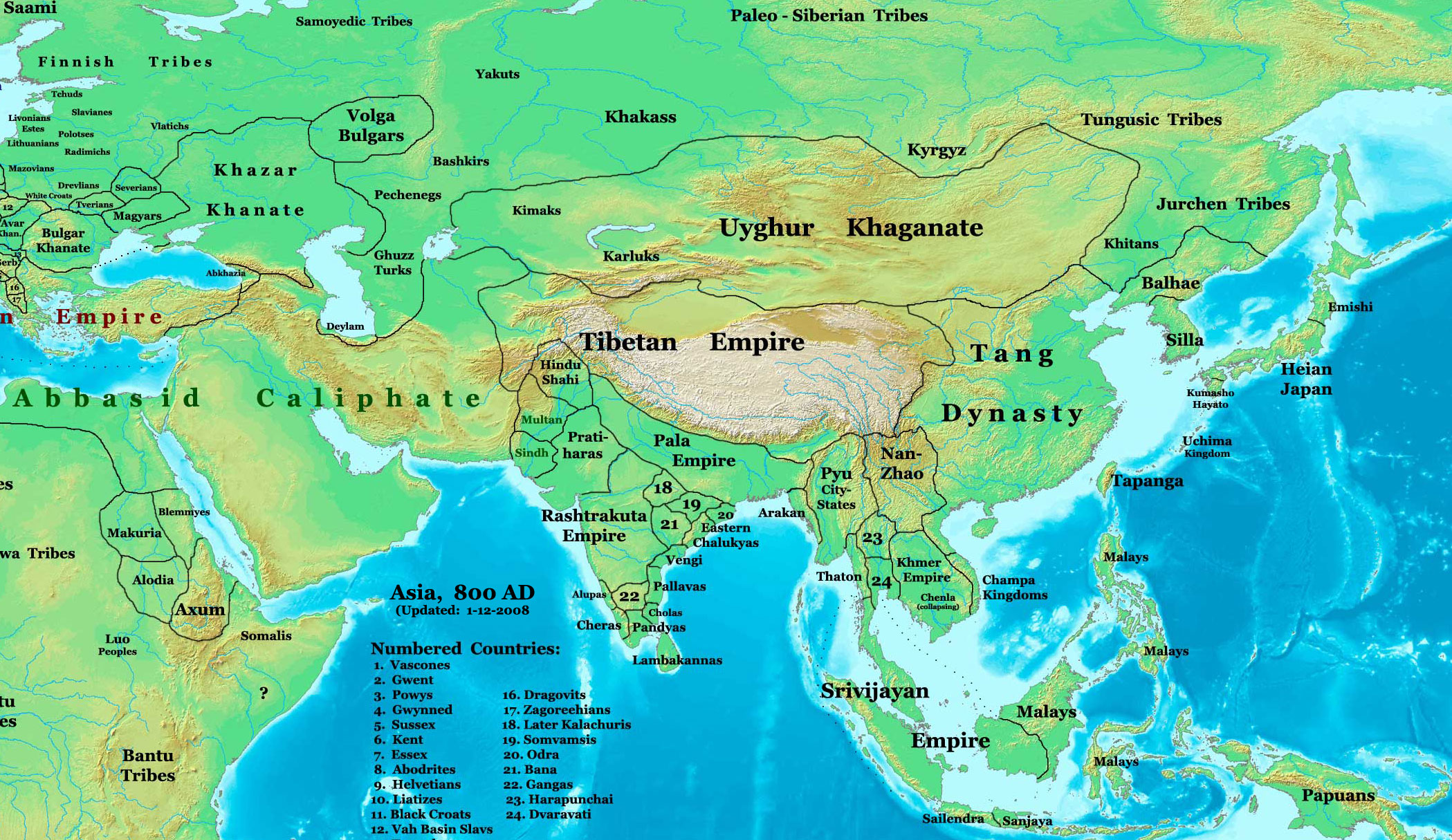
English: This image is a zoomed-in version of Image:East-Hem_800ad.jpg (Eastern Hemisphere in 800 AD).
Author: Thomas A. Lessman. Source URL: http://www.ThomasLessman.com/History/images/East-Hem_800ad.jpg. Image was created by me (Thomas Lessman) based on map of Eastern Hemisphere in 800 AD. Image is free for public and/or educational use. I would appreciate a mention if this image is used elsewhere. If anyone is interested in helping further this work, please contact Thomas Lessman at [email protected]. Other Historical Maps by Thomas Lessman
|
| ရက်စွဲ | ၂၂ အောက်တိုဘာ ၂၀၀၇ (original upload date); ၂၉ ဇန်နဝါရီ ၂၀၀၈ (last version) |
| ရင်းမြစ် | Transferred from en.wikipedia to Commons by Vinhtantran using CommonsHelper. |
| စာရေးသူ | Talessman at အင်္ဂလိပ် ဝီကီပီးဒီးယား |
| အခြား ဗားရှင်းများ |
 |


လိုင်စင်သတ်မှတ်ခြင်း
Talessman at အင်္ဂလိပ် ဝီကီပီးဒီးယား၊ ဤလုပ်ဆောင်ချက်၏ မူပိုင်ခွင့်ပိုင်ရှင်အနေဖြင့် ဤနေရာမှ အောက်ပါလိုင်စင်များအောက်တွင် ထုတ်လွှင့်ပါသည်:

|
ဤစာတမ်းကို GNU Free Documentation License, ဗားရှင်း ၁.၂ သို့မဟုတ် Free Software Foundation မှ ဖြန့်ချီထားသော မည်သည့်ယခင်ဗားရှင်းတစ်ခုခုအောက်တွင် Invariant Sections, Front-Cover Texts နှင့် Back-Cover Texts များမပါဝင်ဘဲ ကူးယူခြင်း၊ ဖြန့်ချီခြင်း နှင့်/သို့မဟုတ် ပြင်ဆင်ပြောင်းလဲနိုင်ရန် ခွင့်ပြုသည်။ လိုင်စင်မူပွားကို GNU Free Documentation License ခေါင်းစဉ်အောက်တွင် ထည့်သွင်းထားသည်။ |
ဤဖိုင်သည် Creative Commons Attribution 3.0 Unported လိုင်စင်အောက်တွင် လိုင်စင်သတ်မှတ်ထားပါသည်။
မှတ်ယူနိုင်ခြင်း: Talessman at အင်္ဂလိပ် ဝီကီပီးဒီးယား
- သင်သည် လွတ်လပ်စွာ:
- မျှဝေရန် – ဖန်တီးမှုကို ကူးယူရန်၊ ဖြန့်ဖြူးရန်နှင့် ထုတ်လွှင့်ရန်
- ပြန်ရောနှောရန် – ဖန်တီးမှုကို ပြင်ဆင်ညှိနှိုင်းရန်
- အောက်ပါ အခြေအနေများတွင်:
- မှတ်ယူနိုင်ခြင်း – ပြောင်းလဲမှုများ ပြုလုပ်ခဲ့ပါက ဖန်တီးသူ သို့မဟုတ် လိုင်စင်ရှိသူမှ သတ်မှတ်သော အမျိုးအစားကို လိုက်နာရမည် (ဆိုလိုသည်မှာ သင့်အား သို့မဟုတ် သင့်ဖန်တီးမှုတွင် အသုံးပြုခြင်းအား ထောက်ခံချက်ပေးသည်ဟု မဆိုလိုပါ)။
သင်အလိုရှိရာ လိုင်စင်ကို ရွေးချယ်နိုင်ပါသည်။
မူရင်းတင်ထားသောမှတ်တမ်း
ဖော်ပြချက် မူရင်းစာမျက်နှာမှာ here ဖြစ်သည်။ အောက်ပါအသုံးပြုသူ အမည်များအားလုံးသည် en.wikipedia ကို ရည်ညွှန်းသည်။
- 2008-01-29 22:50 Talessman 2099×1215×8 (828763 bytes) corrected borders of Tibet and others
- 2007-12-10 23:50 Talessman 2106×1450×8 (911289 bytes) (Correct image uploaded this time; earlier upload was the old version...)
- 2007-12-10 23:48 Talessman 1950×1193×8 (695931 bytes) Uploaded most recently corrected version (as of 12-09-2007)
- 2007-10-31 20:39 Talessman 1950×1193×8 (695931 bytes) Corrected borders of Korea, added info on Far eastern islands
- 2007-10-22 19:15 Talessman 1673×1062×8 (553343 bytes) Author: Thomas A. Lessman. Source URL: http://www.ThomasLessman.com/History/images/East-Hem_800ad.jpg. Image was created by me (Thomas Lessman) based on map of Eastern Hemisphere in 800AD. Image is free for public and/or educational use. I would appreciat
ဖိုင်မှတ်တမ်း
ဖိုင်ကို ယင်းနေ့စွဲ အတိုင်း မြင်နိုင်ရန် နေ့စွဲ/အချိန် တစ်ခုခုပေါ်တွင် ကလစ်နှိပ်ပါ။
| နေ့စွဲ/အချိန် | နမူနာပုံငယ် | မှတ်တမ်း ဒိုင်မန်းရှင်းများ | အသုံးပြုသူ | မှတ်ချက် | |
|---|---|---|---|---|---|
| ကာလပေါ် | ၀၄:၄၆၊ ၂၃ ဇွန် ၂၀၀၈ | | ၂၀၉၉ × ၁၂၁၅ (၈၀၉ KB) | File Upload Bot (Magnus Manske) | {{BotMoveToCommons|en.wikipedia}} {{Information |Description={{en|This image is a zoomed-in version of [http://en.wikipedia.org/wiki/Image:East-Hem_800ad.jpg Eastern Hemisphere in 800 AD]. [[:en:Image:East-Hem_800ad.jpg|thumb|300px|left|Eastern Hemispher |
ဖိုင်သုံးစွဲမှု
အောက်ပါ စာမျက်နှာ သည် ဤဖိုင်ကို အသုံးပြုထားသည်:
ဂလိုဘယ် ဖိုင်သုံးစွဲမှု
အောက်ပါ အခြားဝီကီများတွင် ဤဖိုင်ကို အသုံးပြုထားသည်-
- ar.wikipedia.org တွင် အသုံးပြုမှု
- azb.wikipedia.org တွင် အသုံးပြုမှု
- ba.wikipedia.org တွင် အသုံးပြုမှု
- bn.wikipedia.org တွင် အသုံးပြုမှု
- en.wikipedia.org တွင် အသုံးပြုမှု
- fa.wikipedia.org တွင် အသုံးပြုမှု
- fr.wikipedia.org တွင် အသုံးပြုမှု
- hi.wikipedia.org တွင် အသုံးပြုမှု
- incubator.wikimedia.org တွင် အသုံးပြုမှု
- it.wikipedia.org တွင် အသုံးပြုမှု
- ka.wikipedia.org တွင် အသုံးပြုမှု
- kn.wikipedia.org တွင် အသုံးပြုမှု
- ko.wikipedia.org တွင် အသုံးပြုမှု
- mai.wikipedia.org တွင် အသုံးပြုမှု
- ne.wikipedia.org တွင် အသုံးပြုမှု
- pt.wikipedia.org တွင် အသုံးပြုမှု
- ru.wikipedia.org တွင် အသုံးပြုမှု
- sl.wikipedia.org တွင် အသုံးပြုမှု
- sq.wikipedia.org တွင် အသုံးပြုမှု
- ta.wikipedia.org တွင် အသုံးပြုမှု
- te.wikipedia.org တွင် အသုံးပြုမှု
- tr.wikipedia.org တွင် အသုံးပြုမှု
- tt.wikipedia.org တွင် အသုံးပြုမှု
- uk.wikipedia.org တွင် အသုံးပြုမှု
- vi.wikipedia.org တွင် အသုံးပြုမှု