
ဖိုင်:Australia-New Guinea (orthographic projection).svg

Size of this PNG preview of this SVG file: ၅၄၁ × ၅၄၁ ပစ်ဇယ်. အခြား ပုံရိပ်ပြတ်သားမှု: ၂၄၀ × ၂၄၀ ပစ်ဇယ် | ၄၈၀ × ၄၈၀ ပစ်ဇယ် | ၇၆၈ × ၇၆၈ ပစ်ဇယ် | ၁၀၂၄ × ၁၀၂၄ ပစ်ဇယ် | ၂၀၄၈ × ၂၀၄၈ ပစ်ဇယ်။
မူရင်းဖိုင် (SVG ဖိုင်, ၅၄၁ × ၅၄၁ pixels ကို အကြံပြုသည်, ဖိုင်အရွယ်အစား - ၂၉၃ KB)
| ဤဖိုင်သည် Wikimedia Commons မှဖြစ်ပြီး အခြားပရောဂျက်များတွင် သုံးကောင်းသုံးလိမ့်မည်။ ယင်း၏ ဖိုင်အကြောင်းစာမျက်နှာ တွင် ဖော်ပြထားချက်ကို အောက်တွင် ပြထားသည်။ Commons သည် မူပိုင်ခွင့်လွတ်လပ်သော မီဒီယာဖိုင်များ သိုလှောင်ထားရာ နေရာ ဖြစ်သည်။ သင်လည်း ပါဝင်ကူညီနိုင်ပါသည်။ |
| ဖော်ပြချက် |
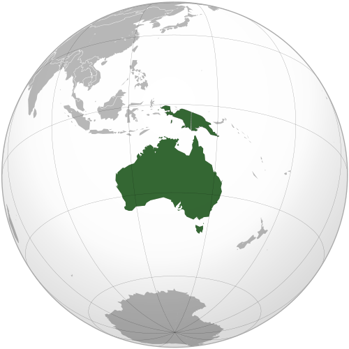
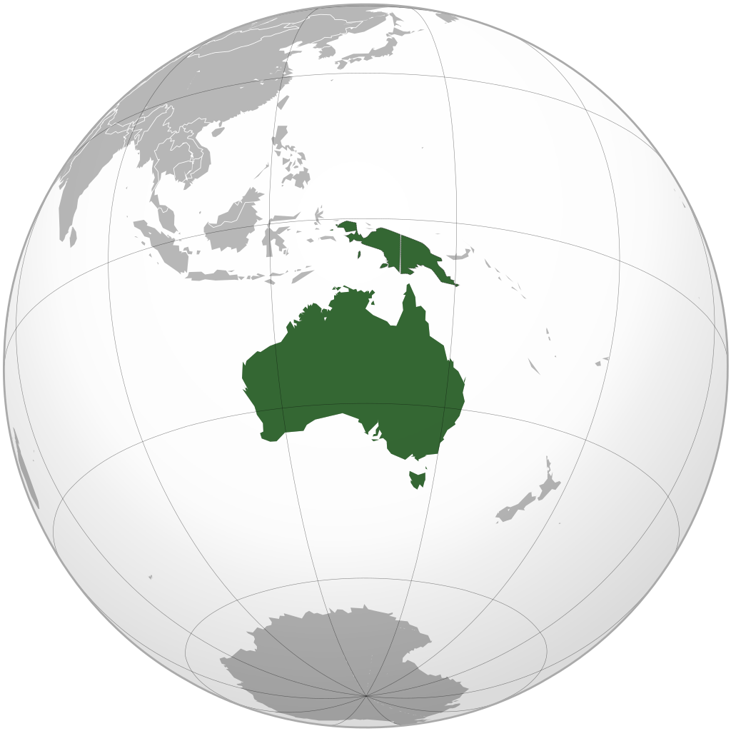
English: Map highlighting the continent of Australia-New Guinea. Includes Australia (including Tasmania), eastern portion of Indonesia (Aru Islands and western New Guinea), and mainland provinces of Papua New Guinea) south/east of Lydekker Line (delimiting continental shelf) |
| ရက်စွဲ | (UTC) |
| ရင်းမြစ် | |
| စာရေးသူ |
|
| အခြား ဗားရှင်းများ |
.svg) |
.svg)
.svg)
.svg)
.svg)
.svg)
.svg)
.svg)
.svg)
.svg)
.svg)
.svg)
.svg)
.svg)
.svg)
.svg)
.svg)
.svg)
.svg)
.svg)
.svg)
.svg)
.svg)
.svg)
.svg)
.svg)
.svg)
.svg)
.svg)
.svg)
.svg)
.svg)
.svg)
.svg)
.svg)
.svg)
.svg)
.svg)
.svg)
.svg)
.svg)
.svg)
.svg)
.svg)
.svg)
.svg)
.svg)
.svg)
.svg)
.svg)
.svg)
.svg)
.svg)
.svg)
.svg)
.svg)
.svg)
.svg)
.svg)
.svg)
.svg)
.svg)
.svg)
.svg)

.svg)
.svg)
.svg)
.svg)
.svg)
.svg)
.svg)
.svg)
.svg)

.svg)

.svg)

.svg)
.svg)
.svg)
.svg)
.svg)
.svg)
.svg)


.svg)
.svg)
.svg)
.svg)
.svg)
.svg)
.svg)

.svg)
.svg)
.svg)
.svg)
.svg)
.svg)
.svg)
.svg)
.svg)
.svg)

.svg)
.svg)
.svg)
.svg)
.svg)
.svg)
.svg)
_without_national_boundaries.svg)
.svg)
.svg)
.svg)
.svg)
.svg)
.svg)

.svg)
.svg)
.png)
.svg)
.svg)
.svg)
.svg)

.svg)
.svg)
.svg)
.svg)
.svg)
.svg)
.svg)
.svg)
.svg)
.svg)
.svg)

.svg)
.svg)
.svg)
.svg)
.svg)
.svg)
.svg)
.svg)
.svg)

.svg)
.svg)

.svg)
.svg)
.svg)
.svg)
.svg)
.svg)
.svg)
.svg)
.svg)
.svg)
.svg)
.svg)
.svg)
.svg)
.svg)
.svg)
.svg)
.svg)
.svg)
.svg)
.svg)
.svg)
.svg)
.svg)
.svg)
.svg)
.svg)
_-_Crimea_disputed.svg)
.svg)
.svg)
.svg)
.svg)
.svg)
.svg)
.svg)
.svg)
.svg)
.svg)
.svg)
_political.svg)
.svg)
.svg)
.svg)
.svg)
_-_Crimea_disputed_-_no_borders.svg)
.svg)
.svg)
.svg)
.svg)
.svg)
.svg)
.svg)
.svg)
.svg)
.svg)
.svg)

.svg)
.svg)
.svg)

.png)
.svg)
.svg)
.svg)
.svg)
.svg)
.svg)
.svg)
.svg)
.svg)
.svg)
.svg)
.svg)
.svg)
.svg)
.svg)
.svg)
.svg)
.svg)
.svg)
.svg)
.svg)
.svg)
.svg)
.svg)
.svg)
.svg)
.svg)
.svg)
.svg)
.svg)
.svg)
.svg)
.svg)
.svg)
.png)
.svg)
.svg)
.svg)
_(orthographic_projection).png)
.svg)
Map includes Australia (including Tasmania and Torres Strait Islands) and New Guinea (including eastern portion of Indonesia (Aru Islands)) and mainland provinces of Papua New Guinea) south/east of Lydekker Line (delimiting continental shelf)
ကျွန်ုပ်၊ ဤလုပ်ဆောင်ချက်၏ မူပိုင်ခွင့်ပိုင်ရှင်အနေဖြင့် ဤနေရာမှ အောက်ပါလိုင်စင်များအောက်တွင် ထုတ်လွှင့်ပါသည်:
| ဤဖိုင်ကို Creative Commons Attribution-Share Alike 3.0 Unported လိုင်စင်ဖြင့် သတ်မှတ်ထားသည်။ | ||
| ||
| This licensing tag was added to this file as part of the GFDL licensing update. |

|
ဤစာတမ်းကို GNU Free Documentation License, ဗားရှင်း ၁.၂ သို့မဟုတ် Free Software Foundation မှ ဖြန့်ချီထားသော မည်သည့်ယခင်ဗားရှင်းတစ်ခုခုအောက်တွင် Invariant Sections, Front-Cover Texts နှင့် Back-Cover Texts များမပါဝင်ဘဲ ကူးယူခြင်း၊ ဖြန့်ချီခြင်း နှင့်/သို့မဟုတ် ပြင်ဆင်ပြောင်းလဲနိုင်ရန် ခွင့်ပြုသည်။ လိုင်စင်မူပွားကို GNU Free Documentation License ခေါင်းစဉ်အောက်တွင် ထည့်သွင်းထားသည်။ |
သင်အလိုရှိရာ လိုင်စင်ကို ရွေးချယ်နိုင်ပါသည်။
The map has been created with the Generic Mapping Tools: https://www.generic-mapping-tools.org/ using one or more of these public-domain datasets for the relief:
|
|
|
ဤစာတမ်းကို GNU Free Documentation License, ဗားရှင်း ၁.၂ သို့မဟုတ် Free Software Foundation မှ ဖြန့်ချီထားသော မည်သည့်ယခင်ဗားရှင်းတစ်ခုခုအောက်တွင် Invariant Sections, Front-Cover Texts နှင့် Back-Cover Texts များမပါဝင်ဘဲ ကူးယူခြင်း၊ ဖြန့်ချီခြင်း နှင့်/သို့မဟုတ် ပြင်ဆင်ပြောင်းလဲနိုင်ရန် ခွင့်ပြုသည်။ လိုင်စင်မူပွားကို GNU Free Documentation License ခေါင်းစဉ်အောက်တွင် ထည့်သွင်းထားသည်။ |
မူရင်းတင်ထားသောမှတ်တမ်း
This image is a derivative work of the following images:
- File:Australia_(orthographic_projection).svg licensed with Cc-by-sa-3.0-migrated, GFDL-GMT
- 2009-08-12T00:17:33Z Addicted04 541x541 (292902 Bytes) Meridianos
- 2008-11-09T13:20:33Z Ssolbergj 541x541 (292870 Bytes) {{Information |Description={{en|1=Australia}} |Source=Own work, {{Inkscape}}[http://www.aquarius.geomar.de/omc/make_map.html Aquarius.geomar.de]{{GFDL-GMT}} |Author=[[User:Ssolbergj|Ssolbergj]] |Date=9 November 2008 |Permissi
Uploaded with derivativeFX
ဖိုင်မှတ်တမ်း
ဖိုင်ကို ယင်းနေ့စွဲ အတိုင်း မြင်နိုင်ရန် နေ့စွဲ/အချိန် တစ်ခုခုပေါ်တွင် ကလစ်နှိပ်ပါ။
| နေ့စွဲ/အချိန် | နမူနာပုံငယ် | မှတ်တမ်း ဒိုင်မန်းရှင်းများ | အသုံးပြုသူ | မှတ်ချက် | |
|---|---|---|---|---|---|
| ကာလပေါ် | ၁၅:၁၅၊ ၁၇ ဖေဖော်ဝါရီ ၂၀၁၆ | | ၅၄၁ × ၅၄၁ (၂၉၃ KB) | Maphobbyist | Reverted to version as of 14:25, 12 December 2009 (UTC) |
| ၀၃:၂၈၊ ၁၉ နိုဝင်ဘာ ၂၀၁၂ |  | ၅၄၁ × ၅၄၁ (၂၈၁ KB) | Kwamikagami | add Outer Banda Arc | |
| ၁၄:၂၅၊ ၁၂ ဒီဇင်ဘာ ၂၀၀၉ |  | ၅၄၁ × ၅၄၁ (၂၉၃ KB) | Avenue | {{Information |Description={{en|1=Continent of Australia-New Guinea}} |Source=*File:Australia_(orthographic_projection).svg |Date=2009-12-12 14:19 (UTC) |Author=*File:Australia_(orthographic_projection).svg: [[User: |
.svg)
ဖိုင်သုံးစွဲမှု
အောက်ပါ 15 စာမျက်နှာများ သည် ဤဖိုင်ကို အသုံးပြုထားသည်:
ဂလိုဘယ် ဖိုင်သုံးစွဲမှု
အောက်ပါ အခြားဝီကီများတွင် ဤဖိုင်ကို အသုံးပြုထားသည်-
- ab.wikipedia.org တွင် အသုံးပြုမှု
- af.wikipedia.org တွင် အသုံးပြုမှု
- ann.wikipedia.org တွင် အသုံးပြုမှု
- ar.wikipedia.org တွင် အသုံးပြုမှု
- آسيا
- أوروبا
- قارة
- أستراليا
- القارة القطبية الجنوبية
- أوقيانوسيا
- أمريكا الشمالية
- أمريكا الجنوبية
- بوابة:آسيا
- بوابة:أوروبا
- العالم الجديد
- أوراسيا
- أطلانطس
- الأمريكتان
- شبه القارة الهندية
- بانجيا
- تصنيف:تصنيفات حسب القارة
- غندوانا
- أفرو-أوراسيا
- أستراليا (قارة)
- تغير أسماء دول آسيا خلال القرن العشرين
- إفريقيا
- ليموريا (قارة)
- القارات في العصر الجوراسي
- قالب:قارات العالم
- أطلانتيكا
- قارة غارقة
- أركتيكا
- آسيامريكا
- بانجيا الأخرى
- أماسيا (قارة)
- لوراسيا
- بانوتيا
ဤဖိုင်ကို အခြားနေရာများတွင် အသုံးပြုထားမှုများအား ကြည့်ရှုရန်။
.svg)
.svg)