
ဖိုင်:Cameroon (orthographic projection).svg

Size of this PNG preview of this SVG file: ၆၀၀ × ၆၀၀ ပစ်ဇယ်. အခြား ပုံရိပ်ပြတ်သားမှု: ၂၄၀ × ၂၄၀ ပစ်ဇယ် | ၄၈၀ × ၄၈၀ ပစ်ဇယ် | ၇၆၈ × ၇၆၈ ပစ်ဇယ် | ၁၀၂၄ × ၁၀၂၄ ပစ်ဇယ် | ၂၀၄၈ × ၂၀၄၈ ပစ်ဇယ်။
မူရင်းဖိုင် (SVG ဖိုင်, ၆၀၀ × ၆၀၀ pixels ကို အကြံပြုသည်, ဖိုင်အရွယ်အစား - ၅၅၉ KB)
| ဤဖိုင်သည် Wikimedia Commons မှဖြစ်ပြီး အခြားပရောဂျက်များတွင် သုံးကောင်းသုံးလိမ့်မည်။ ယင်း၏ ဖိုင်အကြောင်းစာမျက်နှာ တွင် ဖော်ပြထားချက်ကို အောက်တွင် ပြထားသည်။ Commons သည် မူပိုင်ခွင့်လွတ်လပ်သော မီဒီယာဖိုင်များ သိုလှောင်ထားရာ နေရာ ဖြစ်သည်။ သင်လည်း ပါဝင်ကူညီနိုင်ပါသည်။ |
အကျဉ်းချုပ်

| ဖော်ပြချက် |
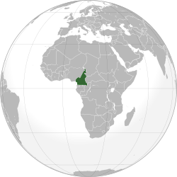
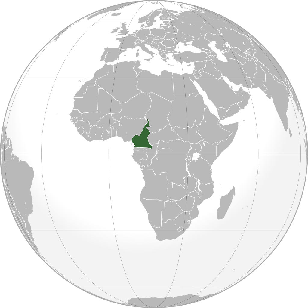
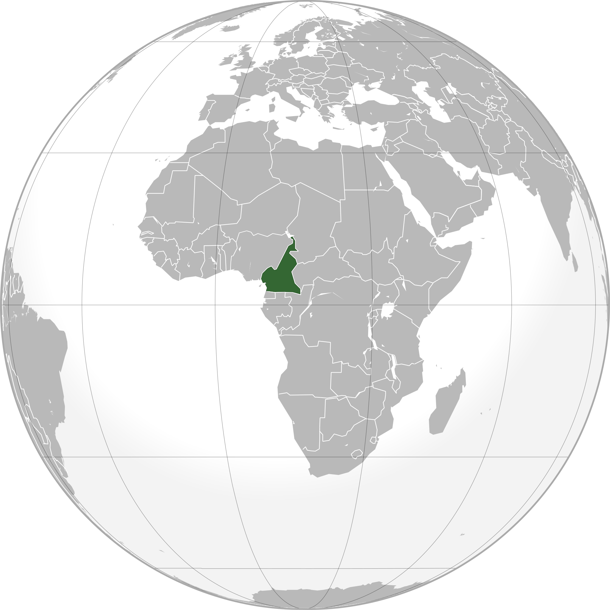
English: Orthographic map of Cameroon
Română: Harta ortogonală a Camerunului. |
|||
| ရက်စွဲ | ||||
| ရင်းမြစ် | File:African Union (orthographic projection).svg | |||
| စာရေးသူ |
MSClaudiu |
|||
| ခွင့်ပြုချက် (ဤဖိုင်ကို ပြန်လည်အသုံးပြုခြင်း) |
|
|||
| အခြား ဗားရှင်းများ |
.svg) |
.svg)
.svg)
.svg)
.svg)
.svg)
.svg)
.svg)
.svg)
.svg)
.svg)
.svg)
.svg)
.svg)
.svg)
.svg)
.svg)
.svg)
.svg)
.svg)
.svg)
.svg)
.svg)
.svg)
.svg)
.svg)
.svg)
.svg)
.svg)
.svg)
.svg)
.svg)
.svg)
.svg)
.svg)
.svg)
.svg)
.svg)
.svg)
.svg)
.svg)
.svg)
.svg)
.svg)
.svg)
.svg)
.svg)
.svg)
.svg)
.svg)
.svg)
.svg)
.svg)
.svg)
.svg)
.svg)
.svg)
.svg)
.svg)
.svg)
.svg)
.svg)
.svg)
.svg)

.svg)
.svg)
.svg)
.svg)
.svg)
.svg)
.svg)
.svg)
.svg)

.svg)

.svg)

.svg)
.svg)
.svg)
.svg)
.svg)
.svg)
.svg)


.svg)
.svg)
.svg)
.svg)
.svg)
.svg)
.svg)

.svg)
.svg)
.svg)
.svg)
.svg)
.svg)
.svg)
.svg)
.svg)
.svg)

.svg)
.svg)
.svg)
.svg)
.svg)
.svg)
.svg)
_without_national_boundaries.svg)
.svg)
.svg)
.svg)
.svg)
.svg)
.svg)

.svg)
.svg)
.png)
.svg)
.svg)
.svg)
.svg)

.svg)
.svg)
.svg)
.svg)
.svg)
.svg)
.svg)
.svg)
.svg)
.svg)
.svg)

.svg)
.svg)
.svg)
.svg)
.svg)
.svg)
.svg)
.svg)
.svg)

.svg)
.svg)

.svg)
.svg)
.svg)
.svg)
.svg)
.svg)
.svg)
.svg)
.svg)
.svg)
.svg)
.svg)
.svg)
.svg)
.svg)
.svg)
.svg)
.svg)
.svg)
.svg)
.svg)
.svg)
.svg)
.svg)
.svg)
.svg)
.svg)
_-_Crimea_disputed.svg)
.svg)
.svg)
.svg)
.svg)
.svg)
.svg)
.svg)
.svg)
.svg)
.svg)
.svg)
_political.svg)
.svg)
.svg)
.svg)
.svg)
_-_Crimea_disputed_-_no_borders.svg)
.svg)
.svg)
.svg)
.svg)
.svg)
.svg)
.svg)
.svg)
.svg)
.svg)
.svg)

.svg)
.svg)
.svg)

.png)
.svg)
.svg)
.svg)
.svg)
.svg)
.svg)
.svg)
.svg)
.svg)
.svg)
.svg)
.svg)
.svg)
.svg)
.svg)
.svg)
.svg)
.svg)
.svg)
.svg)
.svg)
.svg)
.svg)
.svg)
.svg)
.svg)
.svg)
.svg)
.svg)
.svg)
.svg)
.svg)
.svg)
.svg)
.png)
.svg)
.svg)
.svg)
_(orthographic_projection).png)
.svg)
.svg)
လိုင်စင်သတ်မှတ်ခြင်း
| I, the copyright holder of this work, release this work into the public domain. This applies worldwide. In some countries this may not be legally possible; if so: အကျွန်ုပ်သည် ဤဖန်တီးမှုလက်ရာကို ဥပဒေအရလိုအပ်ခြင်းမရှိသည့် မည်သည့်အခြေအနေမျိုးတွက်မဆို၊ မည်သို့သော ရည်ရွယ်ချက်အတွက်မဆို ၎င်းကို မည်သူမဆို အသုံးပြုပိုင်ခွင့်အား ပေးအပ်သည်။ |
ဖိုင်မှတ်တမ်း
ဖိုင်ကို ယင်းနေ့စွဲ အတိုင်း မြင်နိုင်ရန် နေ့စွဲ/အချိန် တစ်ခုခုပေါ်တွင် ကလစ်နှိပ်ပါ။
| နေ့စွဲ/အချိန် | နမူနာပုံငယ် | မှတ်တမ်း ဒိုင်မန်းရှင်းများ | အသုံးပြုသူ | မှတ်ချက် | |
|---|---|---|---|---|---|
| ကာလပေါ် | ၁၅:၂၆၊ ၃၀ မတ် ၂၀၂၅ | | ၆၀၀ × ၆၀၀ (၅၅၉ KB) | M.Bitton | + title |
| ၁၄:၅၉၊ ၃၀ မတ် ၂၀၂၅ |  | ၆၀၀ × ၆၀၀ (၅၅၉ KB) | M.Bitton | lighter colour (closer to the original) | |
| ၁၄:၅၁၊ ၃၀ မတ် ၂၀၂၅ |  | ၆၀၀ × ၆၀၀ (၅၅၉ KB) | M.Bitton | Same map (cleaner version) | |
| ၁၄:၁၇၊ ၃၀ မတ် ၂၀၂၅ |  | ၅၅၀ × ၅၅၀ (၁၅၇ KB) | M.Bitton | Reverted to version as of 16:43, 15 July 2011 (UTC): per COM:OVERWRITE | |
| ၂၂:၅၀၊ ၂၉ မတ် ၂၀၂၅ |  | ၅၅၀ × ၅၅၀ (၃.၄၆ MB) | Remsense | fully algorithmically generated locator map via https://observablehq.com/@mikima/wikipedia-grey-green-orthographic-projections-maps-gener/2, resolving glaring longstanding border glitches | |
| ၂၂:၂၁၊ ၂၉ မတ် ၂၀၂၅ |  | ၅၅၀ × ၅၅၀ (၂.၆၉ MB) | Remsense | fully algorithmically generated locator map via https://observablehq.com/@mikima/draggable-svg-world-map, resolving glaring longstanding border glitches | |
| ၁၆:၄၃၊ ၁၅ ဇူလိုင် ၂၀၁၁ |  | ၅၅၀ × ၅၅၀ (၁၅၇ KB) | Mixx321 | South Sudan | |
| ၂၀:၀၀၊ ၂ ဖေဖော်ဝါရီ ၂၀၁၁ |  | ၅၅၀ × ၅၅၀ (၁၅၆ KB) | MSClaudiu | changed color | |
| ၁၄:၃၅၊ ၃၁ ဇန်နဝါရီ ၂၀၁၁ |  | ၅၅၀ × ၅၅၀ (၁၅၄ KB) | MSClaudiu | {{Information |Description ={{en|1=Orthographic map of Cameroon}} {{ro|1=Harta ortogonală a Camerunului.}} |Source ={{own}} |Author =MSClaudiu |Date =2010-01-31 |Permission = |other_versions = }} |
ဖိုင်သုံးစွဲမှု
အောက်ပါ 4 စာမျက်နှာများ သည် ဤဖိုင်ကို အသုံးပြုထားသည်:
ဂလိုဘယ် ဖိုင်သုံးစွဲမှု
အောက်ပါ အခြားဝီကီများတွင် ဤဖိုင်ကို အသုံးပြုထားသည်-
- ann.wikipedia.org တွင် အသုံးပြုမှု
- ar.wikipedia.org တွင် အသုံးပြုမှု
- as.wikipedia.org တွင် အသုံးပြုမှု
- avk.wikipedia.org တွင် အသုံးပြုမှု
- av.wikipedia.org တွင် အသုံးပြုမှု
- awa.wikipedia.org တွင် အသုံးပြုမှု
- azb.wikipedia.org တွင် အသုံးပြုမှု
- az.wiktionary.org တွင် အသုံးပြုမှု
- ban.wikipedia.org တွင် အသုံးပြုမှု
- ba.wikipedia.org တွင် အသုံးပြုမှု
- bbc.wikipedia.org တွင် အသုံးပြုမှု
- be.wikipedia.org တွင် အသုံးပြုမှု
- bew.wikipedia.org တွင် အသုံးပြုမှု
- bg.wikipedia.org တွင် အသုံးပြုမှု
- bh.wikipedia.org တွင် အသုံးပြုမှု
- bi.wikipedia.org တွင် အသုံးပြုမှု
- blk.wikipedia.org တွင် အသုံးပြုမှု
- bn.wikipedia.org တွင် အသုံးပြုမှု
- cdo.wikipedia.org တွင် အသုံးပြုမှု
- ceb.wikipedia.org တွင် အသုံးပြုမှု
- chr.wikipedia.org တွင် အသုံးပြုမှု
- ch.wikipedia.org တွင် အသုံးပြုမှု
- ckb.wikipedia.org တွင် အသုံးပြုမှု
- da.wikipedia.org တွင် အသုံးပြုမှု
- dty.wikipedia.org တွင် အသုံးပြုမှု
- dv.wikipedia.org တွင် အသုံးပြုမှု
- el.wikipedia.org တွင် အသုံးပြုမှု
- en.wikipedia.org တွင် အသုံးပြုမှု
ဤဖိုင်ကို အခြားနေရာများတွင် အသုံးပြုထားမှုများအား ကြည့်ရှုရန်။
.svg)
.svg)