မာတိကာသို့ ခုန်သွားရန်

ဖိုင်:Carte Topo Region Teheran.png

အခြားဘာသာစကားများဖြင့် စာမျက်နှာအကြောင်းအရာများကို ပံ့ပိုးမထားပါ။
This is a file from the Wikimedia Commons
ဝီကီပီးဒီးယား မှ

မူရင်းဖိုင် (၂၁၇၆ × ၂၃၀၀ pixels, ဖိုင်အရွယ်အစား - ၃.၈၉ MB, MIME အမျိုးအစား image/png)

အကျဉ်းချုပ်

ဖော်ပြချက်
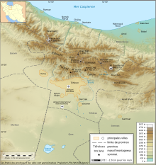
English: Topographic map in French of the Tehran area in Iran.
Note : The shaded relief is a raster image embedded in the SVG file.
Français : Carte topographique en français de la région de fr:Téhéran (Iran).
Note : Le relief ombré est une image bitmap embarquée dans le fichier SVG.

UTM projection ; WGS84 datum ; shaded relief (composite image of N-W, W and N lightning positions) ;
Approximate scales:

  • Topography: 1:372,000 (precision: 93 m) ;
ရက်စွဲ
ရင်းမြစ်

http://www.liranpourlesnuls.net/cartes/carte-teheran-et-sa-region/

စာရေးသူ Fabien Dany
ခွင့်ပြုချက်
(ဤဖိုင်ကို ပြန်လည်အသုံးပြုခြင်း)

L'utilisation est autorisée selon les termes ci-dessous et à condition de citer comme source : L'Iran pour les nuls www.liranpourlesnuls.net. Un email serait aussi grandement apprécié.

အခြား ဗားရှင်းများ
SVG Version
Camera location၃၅° ၄၃′ ၃၆.၃″ N, ၅၁° ၂၆′ ၂၆.၆″ E Kartographer map based on OpenStreetMap.View this and other nearby images on: OpenStreetMapinfo

လိုင်စင်သတ်မှတ်ခြင်း

w:my:Creative Commons
မှတ်ယူနိုင်ခြင်း ထပ်တူမျှဝေ
ဤဖိုင်ကို Creative Commons Attribution-Share Alike 3.0 Unported လိုင်စင်ဖြင့် သတ်မှတ်ထားသည်။
သင်သည် လွတ်လပ်စွာ:
  • မျှဝေရန် – ဖန်တီးမှုကို ကူးယူရန်၊ ဖြန့်ဖြူးရန်နှင့် ထုတ်လွှင့်ရန်
  • ပြန်ရောနှောရန် – ဖန်တီးမှုကို ပြင်ဆင်ညှိနှိုင်းရန်
အောက်ပါ အခြေအနေများတွင်:
  • မှတ်ယူနိုင်ခြင်း – ပြောင်းလဲမှုများ ပြုလုပ်ခဲ့ပါက ဖန်တီးသူ သို့မဟုတ် လိုင်စင်ရှိသူမှ သတ်မှတ်သော အမျိုးအစားကို လိုက်နာရမည် (ဆိုလိုသည်မှာ သင့်အား သို့မဟုတ် သင့်ဖန်တီးမှုတွင် အသုံးပြုခြင်းအား ထောက်ခံချက်ပေးသည်ဟု မဆိုလိုပါ)။
  • ထပ်တူမျှဝေ – ဤဖန်တီးမှုအား ပြင်ဆင်ခြင်း၊ ပြောင်းလဲခြင်း သို့မဟုတ် ထပ်ဆင့် ဖန်တီးခြင်း ပြုလုပ်ပါက ရရှိလာသော ဖန်တီးမှုကို ဤဖန်တီးမှုနှင့် သို့မဟုတ် ဆင်တူသော လိုင်စင်ဖြင့်သာ ဖြန့်ချိသင့်သည်။

This image has been assessed using the Quality image guidelines and is considered a Quality image.

العربية  جازايرية  беларуская  беларуская (тарашкевіца)  български  বাংলা  català  čeština  Cymraeg  Deutsch  Schweizer Hochdeutsch  Zazaki  Ελληνικά  English  Esperanto  español  eesti  euskara  فارسی  suomi  français  galego  עברית  हिन्दी  hrvatski  magyar  հայերեն  Bahasa Indonesia  italiano  日本語  Jawa  ქართული  Qaraqalpaqsha  한국어  kurdî  кыргызча  Latina  Lëtzebuergesch  lietuvių  македонски  മലയാളം  मराठी  Bahasa Melayu  Nederlands  Norfuk / Pitkern  polski  português  português do Brasil  rumantsch  română  русский  sicilianu  slovenčina  slovenščina  shqip  српски / srpski  svenska  தமிழ்  తెలుగు  ไทย  Tagalog  toki pona  Türkçe  українська  oʻzbekcha / ўзбекча  vèneto  Tiếng Việt  中文  中文(简体)  中文(繁體)  +/−

ပုံစာများ

ဤဖိုင်၏ဆိုလိုရင်းကို စာတစ်ကြောင်းရှင်းလင်းချက်ဖြင့် ထည့်သွင်းရန်

Items portrayed in this file

depicts အင်္ဂလိပ်

Commons quality assessment အင်္ဂလိပ်

Wikimedia Commons quality image အင်္ဂလိပ်

၃၀ ဇန်နဝါရီ 2011

coordinates of the point of view အင်္ဂလိပ်

35°43'36.300"N, 51°26'26.599"E

media type အင်္ဂလိပ်

image/png

checksum အင်္ဂလိပ်

c3e24f997840df1ca2f829fae132b8269ef95080

determination method or standard အင်္ဂလိပ်: SHA-1

data size အင်္ဂလိပ်

၄၀၇၉၄၈၂ ဘိုက်

height အင်္ဂလိပ်

၂၃၀၀ pixel

width အင်္ဂလိပ်

၂၁၇၆ pixel

ဖိုင်မှတ်တမ်း

ဖိုင်ကို ယင်းနေ့စွဲ အတိုင်း မြင်နိုင်ရန် နေ့စွဲ/အချိန် တစ်ခုခုပေါ်တွင် ကလစ်နှိပ်ပါ။

နေ့စွဲ/အချိန်နမူနာပုံငယ်မှတ်တမ်း ဒိုင်မန်းရှင်းများအသုံးပြုသူမှတ်ချက်
ကာလပေါ် ၂၂:၁၁၊ ၃၀ ဇန်နဝါရီ ၂၀၁၁ ၂၂:၁၁၊ ၃၀ ဇန်နဝါရီ ၂၀၁၁ ရက်က မူအတွက် နမူနာပုံငယ်၂၁၇၆ × ၂၃၀၀ (၃.၈၉ MB)Fabienkhan{{Information |Description ={{en|1=Topographic map in French of the Tehran area in Iran.<br/>''Note :'' The shaded relief is a raster image embedded in the SVG file.}} {{fr|1=Carte topographique en français de la région de [[:fr:Téhé

အောက်ပါ စာမျက်နှာ သည် ဤဖိုင်ကို အသုံးပြုထားသည်:

ဂလိုဘယ် ဖိုင်သုံးစွဲမှု

အောက်ပါ အခြားဝီကီများတွင် ဤဖိုင်ကို အသုံးပြုထားသည်-

  • ar.wikipedia.org တွင် အသုံးပြုမှု
  • ckb.wikipedia.org တွင် အသုံးပြုမှု
  • cs.wikipedia.org တွင် အသုံးပြုမှု
  • en.wikipedia.org တွင် အသုံးပြုမှု
  • fa.wikipedia.org တွင် အသုံးပြုမှု
  • fr.wikipedia.org တွင် အသုံးပြုမှု
  • incubator.wikimedia.org တွင် အသုံးပြုမှု
  • mg.wikipedia.org တွင် အသုံးပြုမှု
  • mt.wikipedia.org တွင် အသုံးပြုမှု
  • vi.wikipedia.org တွင် အသုံးပြုမှု
  • www.wikidata.org တွင် အသုံးပြုမှု