
ဖိုင်:EU-Cyprus.svg

Size of this PNG preview of this SVG file: ၇၁၃ × ၆၀၀ ပစ်ဇယ်. အခြား ပုံရိပ်ပြတ်သားမှု: ၂၈၅ × ၂၄၀ ပစ်ဇယ် | ၅၇၁ × ၄၈၀ ပစ်ဇယ် | ၉၁၃ × ၇၆၈ ပစ်ဇယ် | ၁၂၁၈ × ၁၀၂၄ ပစ်ဇယ် | ၂၄၃၅ × ၂၀၄၈ ပစ်ဇယ် | ၂၀၄၅ × ၁၇၂၀ ပစ်ဇယ်။
မူရင်းဖိုင် (SVG ဖိုင်, ၂၀၄၅ × ၁၇၂၀ pixels ကို အကြံပြုသည်, ဖိုင်အရွယ်အစား - ၇.၃၁ MB)
| ဤဖိုင်သည် Wikimedia Commons မှဖြစ်ပြီး အခြားပရောဂျက်များတွင် သုံးကောင်းသုံးလိမ့်မည်။ ယင်း၏ ဖိုင်အကြောင်းစာမျက်နှာ တွင် ဖော်ပြထားချက်ကို အောက်တွင် ပြထားသည်။ Commons သည် မူပိုင်ခွင့်လွတ်လပ်သော မီဒီယာဖိုင်များ သိုလှောင်ထားရာ နေရာ ဖြစ်သည်။ သင်လည်း ပါဝင်ကူညီနိုင်ပါသည်။ |
အကျဉ်းချုပ်
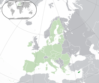
Português:
(Verde) Chipre.
(Verde-claro) União Europeia (EU).
(Cinzento) Europa.
(Cinzento-claro) Paises circundantes.
| ဖော်ပြချက် |
bright-green: Turkish Republic of Northern Cyprus English: (Dark-Green) Cyprus. (Light-Green) The rest of the European Union (EU). (Dark-gray) The rest of Europe. (Light-gray) The surrounding region.
See also: |
| SVG genesis | |
| ရက်စွဲ | |
| ရင်းမြစ် | |
| စာရေးသူ | NuclearVacuum |
| အခြား ဗားရှင်းများ |
Derivative works of this file: Norhern Cyprus (orthographic projection).png |
| SVG genesis |


.png)
လိုင်စင်သတ်မှတ်ခြင်း
ကျွန်ုပ်၊ ဤလုပ်ဆောင်ချက်၏ မူပိုင်ခွင့်ပိုင်ရှင်အနေဖြင့် ဤနေရာမှ အောက်ပါလိုင်စင်များအောက်တွင် ထုတ်လွှင့်ပါသည်:
ဤဖိုင်ကို Creative Commons Attribution-Share Alike 3.0 Unported လိုင်စင်ဖြင့် သတ်မှတ်ထားသည်။
- သင်သည် လွတ်လပ်စွာ:
- မျှဝေရန် – ဖန်တီးမှုကို ကူးယူရန်၊ ဖြန့်ဖြူးရန်နှင့် ထုတ်လွှင့်ရန်
- ပြန်ရောနှောရန် – ဖန်တီးမှုကို ပြင်ဆင်ညှိနှိုင်းရန်
- အောက်ပါ အခြေအနေများတွင်:
- မှတ်ယူနိုင်ခြင်း – ပြောင်းလဲမှုများ ပြုလုပ်ခဲ့ပါက ဖန်တီးသူ သို့မဟုတ် လိုင်စင်ရှိသူမှ သတ်မှတ်သော အမျိုးအစားကို လိုက်နာရမည် (ဆိုလိုသည်မှာ သင့်အား သို့မဟုတ် သင့်ဖန်တီးမှုတွင် အသုံးပြုခြင်းအား ထောက်ခံချက်ပေးသည်ဟု မဆိုလိုပါ)။
- ထပ်တူမျှဝေ – ဤဖန်တီးမှုအား ပြင်ဆင်ခြင်း၊ ပြောင်းလဲခြင်း သို့မဟုတ် ထပ်ဆင့် ဖန်တီးခြင်း ပြုလုပ်ပါက ရရှိလာသော ဖန်တီးမှုကို ဤဖန်တီးမှုနှင့် သို့မဟုတ် ဆင်တူသော လိုင်စင်ဖြင့်သာ ဖြန့်ချိသင့်သည်။

|
ဤစာတမ်းကို GNU Free Documentation License, ဗားရှင်း ၁.၂ သို့မဟုတ် Free Software Foundation မှ ဖြန့်ချီထားသော မည်သည့်ယခင်ဗားရှင်းတစ်ခုခုအောက်တွင် Invariant Sections, Front-Cover Texts နှင့် Back-Cover Texts များမပါဝင်ဘဲ ကူးယူခြင်း၊ ဖြန့်ချီခြင်း နှင့်/သို့မဟုတ် ပြင်ဆင်ပြောင်းလဲနိုင်ရန် ခွင့်ပြုသည်။ လိုင်စင်မူပွားကို GNU Free Documentation License ခေါင်းစဉ်အောက်တွင် ထည့်သွင်းထားသည်။ |
သင်အလိုရှိရာ လိုင်စင်ကို ရွေးချယ်နိုင်ပါသည်။
ဖိုင်မှတ်တမ်း
ဖိုင်ကို ယင်းနေ့စွဲ အတိုင်း မြင်နိုင်ရန် နေ့စွဲ/အချိန် တစ်ခုခုပေါ်တွင် ကလစ်နှိပ်ပါ။
| နေ့စွဲ/အချိန် | နမူနာပုံငယ် | မှတ်တမ်း ဒိုင်မန်းရှင်းများ | အသုံးပြုသူ | မှတ်ချက် | |
|---|---|---|---|---|---|
| ကာလပေါ် | ၁၅:၁၆၊ ၁ ဖေဖော်ဝါရီ ၂၀၂၀ | | ၂၀၄၅ × ၁၇၂၀ (၇.၃၁ MB) | Thom.lanaud | Re-up |
| ၁၅:၁၃၊ ၁ ဖေဖော်ဝါရီ ၂၀၂၀ |  | ၂၀၄၅ × ၁၇၂၀ (၇.၃၁ MB) | Thom.lanaud | Minus the UK and Gibraltar + the Channel Islands, which were never part of the EU | |
| ၁၆:၃၇၊ ၂၅ အောက်တိုဘာ ၂၀၁၆ |  | ၂၀၄၅ × ၁၇၂၀ (၇.၃၃ MB) | Giorgi Balakhadze | Rv of sockpuppet and per COM:OVERWRITE | |
| ၀၄:၁၀၊ ၂၄ ဖေဖော်ဝါရီ ၂၀၁၅ |  | ၂၀၄၅ × ၁၇၂၀ (၇.၃၈ MB) | Leftcry | Reverted to version as of 19:36, 16 November 2014 Really messed up the visual | |
| ၁၄:၀၅၊ ၂၁ ဖေဖော်ဝါရီ ၂၀၁၅ |  | ၂၀၄၅ × ၁၇၂၀ (၂.၈၉ MB) | Renamed user c97caec71d4b1be7ce73d4a53e2ab940 | Spain. Greece. Slovakia. Cyprus. Romania VETO | |
| ၁၉:၃၆၊ ၁၆ နိုဝင်ဘာ ၂၀၁၄ |  | ၂၀၄၅ × ၁၇၂၀ (၇.၃၈ MB) | Leftcry | Reverted to version as of 11:31, 9 September 2014 Please go to your talk page | |
| ၁၆:၂၂၊ ၁၆ နိုဝင်ဘာ ၂၀၁၄ |  | ၂၀၄၅ × ၁၇၂၀ (၂.၈၉ MB) | A2D2 | The map must show the original de-jure status with no breakaway regions, as it was originally created. An alternative map showing the de-facto status with breakaway regions needs to be created instead. | |
| ၁၁:၃၁၊ ၉ စက်တင်ဘာ ၂၀၁၄ |  | ၂၀၄၅ × ၁၇၂၀ (၇.၃၈ MB) | Rob984 | Cyprus is not within Europe. Insert unnecessary. Other General improvements. | |
| ၀၈:၄၆၊ ၁ ဇူလိုင် ၂၀၁၃ |  | ၂၀၄၅ × ၁၇၂၀ (၂.၈၉ MB) | U5K0 | croatia | |
| ၂၀:၂၅၊ ၂၈ မေ ၂၀၁၂ |  | ၂၀၄၅ × ၁၇၂၀ (၂.၈၈ MB) | Chipmunkdavis | Increasing the detail of the inset using the image from File:Akrotiri and Dhekelia in United Kingdom.svg, greying out Akrotiri and Dhekelia, and increasing the lightness of the breakaway north while adding small black lines illustrating UN buffer zone ... |
ဖိုင်သုံးစွဲမှု
အောက်ပါ 3 စာမျက်နှာများ သည် ဤဖိုင်ကို အသုံးပြုထားသည်:
ဂလိုဘယ် ဖိုင်သုံးစွဲမှု
အောက်ပါ အခြားဝီကီများတွင် ဤဖိုင်ကို အသုံးပြုထားသည်-
- af.wikipedia.org တွင် အသုံးပြုမှု
- ami.wikipedia.org တွင် အသုံးပြုမှု
- an.wikipedia.org တွင် အသုံးပြုမှု
- arc.wikipedia.org တွင် အသုံးပြုမှု
- ar.wikipedia.org တွင် အသုံးပြုမှု
- ar.wiktionary.org တွင် အသုံးပြုမှု
- as.wikipedia.org တွင် အသုံးပြုမှု
- azb.wikipedia.org တွင် အသုံးပြုမှု
- az.wikipedia.org တွင် အသုံးပြုမှု
- bcl.wikipedia.org တွင် အသုံးပြုမှု
- be-tarask.wikipedia.org တွင် အသုံးပြုမှု
- bew.wikipedia.org တွင် အသုံးပြုမှု
- bh.wikipedia.org တွင် အသုံးပြုမှု
- bi.wikipedia.org တွင် အသုံးပြုမှု
- bn.wikipedia.org တွင် အသုံးပြုမှု
- bo.wikipedia.org တွင် အသုံးပြုမှု
- br.wikipedia.org တွင် အသုံးပြုမှု
- ca.wikipedia.org တွင် အသုံးပြုမှု
- cbk-zam.wikipedia.org တွင် အသုံးပြုမှု
- cdo.wikipedia.org တွင် အသုံးပြုမှု
- chr.wikipedia.org တွင် အသုံးပြုမှု
- ckb.wikipedia.org တွင် အသုံးပြုမှု
- co.wikipedia.org တွင် အသုံးပြုမှု
- cs.wikipedia.org တွင် အသုံးပြုမှု
- da.wikipedia.org တွင် အသုံးပြုမှု
- de.wikipedia.org တွင် အသုံးပြုမှု
- dtp.wikipedia.org တွင် အသုံးပြုမှု
- el.wikipedia.org တွင် အသုံးပြုမှု
- en.wikipedia.org တွင် အသုံးပြုမှု
ဤဖိုင်ကို အခြားနေရာများတွင် အသုံးပြုထားမှုများအား ကြည့်ရှုရန်။