
ဖိုင်:France departements regions narrow.jpg

သည်ထက်ကြီးသော resolution မရှိပါ.
France_departements_regions_narrow.jpg (၅၂၀ × ၅၅၀ pixels, ဖိုင်အရွယ်အစား - ၆၈ KB, MIME အမျိုးအစား image/jpeg)
| ဤဖိုင်သည် Wikimedia Commons မှဖြစ်ပြီး အခြားပရောဂျက်များတွင် သုံးကောင်းသုံးလိမ့်မည်။ ယင်း၏ ဖိုင်အကြောင်းစာမျက်နှာ တွင် ဖော်ပြထားချက်ကို အောက်တွင် ပြထားသည်။ Commons သည် မူပိုင်ခွင့်လွတ်လပ်သော မီဒီယာဖိုင်များ သိုလှောင်ထားရာ နေရာ ဖြစ်သည်။ သင်လည်း ပါဝင်ကူညီနိုင်ပါသည်။ |
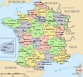
| ဖော်ပြချက် | Map of official départements and régions of France, with French titles (in JPEG format for larger, rapid display: 5x faster than SVG). French: Départements et régions, en Francais. | ||
| ရက်စွဲ | |||
| ရင်းမြစ် | Image:Départements+régions (France).svg (Wikimedia file, converted to quick JPEG and narrowed 15%) | ||
| စာရေးသူ | self (after User:Historicair 6-Nov-2006) | ||
| ခွင့်ပြုချက် (ဤဖိုင်ကို ပြန်လည်အသုံးပြုခြင်း) |
|
||
| အခြား ဗားရှင်းများ | Wider view, large 254kb SVG file: Image:Départements+régions (France).svg |

|
File:Départements+régions (France).svg is a vector version of this file. It should be used in place of this JPG file.
File:France departements regions narrow.jpg → File:Départements+régions (France).svg
For more information, see Help:SVG. |
.svg) |
Variations
-
 CURRENT IMAGE: Départements 520px (15% magnified, rapid JPEG format)
 -
 Départements 588px (régions en lettres et colorisé, wider view, same labels, SVG format 5x slower)
 -
 Départements sans colorisé (numeric labels, uncolorized)
 -
 Départements de France avec un découpage régional


ဖိုင်မှတ်တမ်း
ဖိုင်ကို ယင်းနေ့စွဲ အတိုင်း မြင်နိုင်ရန် နေ့စွဲ/အချိန် တစ်ခုခုပေါ်တွင် ကလစ်နှိပ်ပါ။
| နေ့စွဲ/အချိန် | နမူနာပုံငယ် | မှတ်တမ်း ဒိုင်မန်းရှင်းများ | အသုံးပြုသူ | မှတ်ချက် | |
|---|---|---|---|---|---|
| ကာလပေါ် | ၁၃:၄၄၊ ၂၁ မတ် ၂၀၀၇ | | ၅၂၀ × ၅၅၀ (၆၈ KB) | Wikid77 | Circled Paris in maroon red color, to tie inset to Paris region. |
| ၁၂:၀၂၊ ၂၁ မတ် ၂၀၀၇ |  | ၅၂၀ × ၅၅၀ (၆၈ KB) | Wikid77 | {{Information |Description=Map of official départements and régions of France, with French titles (in JPEG format for larger, rapid display: 5x faster than SVG). ''French:'' Départements et régions, en Francais. |Source=[[:Image:Départements+région |
ဖိုင်သုံးစွဲမှု
အောက်ပါ စာမျက်နှာ သည် ဤဖိုင်ကို အသုံးပြုထားသည်:
ဂလိုဘယ် ဖိုင်သုံးစွဲမှု
အောက်ပါ အခြားဝီကီများတွင် ဤဖိုင်ကို အသုံးပြုထားသည်-
- azb.wikipedia.org တွင် အသုံးပြုမှု
- be.wikipedia.org တွင် အသုံးပြုမှု
- ca.wikipedia.org တွင် အသုံးပြုမှု
- cs.wikipedia.org တွင် အသုံးပြုမှု
- en.wikipedia.org တွင် အသုံးပြုမှု
- fa.wikipedia.org တွင် အသုံးပြုမှု
- fr.wikipedia.org တွင် အသုံးပြုမှု
- hu.wikipedia.org တွင် အသုံးပြုမှု
- hy.wikipedia.org တွင် အသုံးပြုမှု
- id.wikipedia.org တွင် အသုံးပြုမှု
- ja.wikipedia.org တွင် အသုံးပြုမှု
- jv.wikipedia.org တွင် အသုံးပြုမှု
- ka.wikipedia.org တွင် အသုံးပြုမှု
- km.wikipedia.org တွင် အသုံးပြုမှု
- mzn.wikipedia.org တွင် အသုံးပြုမှု
- nn.wikipedia.org တွင် အသုံးပြုမှု
- sk.wikipedia.org တွင် အသုံးပြုမှု
- sl.wikipedia.org တွင် အသုံးပြုမှု
- sr.wikipedia.org တွင် အသုံးပြုမှု
- sv.wikipedia.org တွင် အသုံးပြုမှု
- te.wikipedia.org တွင် အသုံးပြုမှု
- tl.wikipedia.org တွင် အသုံးပြုမှု
- tr.wiktionary.org တွင် အသုံးပြုမှု
- tt.wikipedia.org တွင် အသုံးပြုမှု
- uk.wikipedia.org တွင် အသုံးပြုမှု
ဤဖိုင်ကို အခြားနေရာများတွင် အသုံးပြုထားမှုများအား ကြည့်ရှုရန်။