
ဖိုင်:Java Topography.png

ဤနမူနာ၏ အရွယ်အစား - ၈၀၀ × ၅၀၄ ပစ်ဇယ်။ အခြား ပုံရိပ်ပြတ်သားမှု: ၃၂၀ × ၂၀၂ ပစ်ဇယ် | ၆၄၀ × ၄၀၃ ပစ်ဇယ် | ၁၀၂၄ × ၆၄၅ ပစ်ဇယ် | ၁၂၈၀ × ၈၀၆ ပစ်ဇယ် | ၂၆၈၈ × ၁၆၉၃ ပစ်ဇယ်။
မူရင်းဖိုင် (၂၆၈၈ × ၁၆၉၃ pixels, ဖိုင်အရွယ်အစား - ၁.၁၆ MB, MIME အမျိုးအစား image/png)
| ဤဖိုင်သည် Wikimedia Commons မှဖြစ်ပြီး အခြားပရောဂျက်များတွင် သုံးကောင်းသုံးလိမ့်မည်။ ယင်း၏ ဖိုင်အကြောင်းစာမျက်နှာ တွင် ဖော်ပြထားချက်ကို အောက်တွင် ပြထားသည်။ Commons သည် မူပိုင်ခွင့်လွတ်လပ်သော မီဒီယာဖိုင်များ သိုလှောင်ထားရာ နေရာ ဖြစ်သည်။ သင်လည်း ပါဝင်ကူညီနိုင်ပါသည်။ |
အကျဉ်းချုပ်
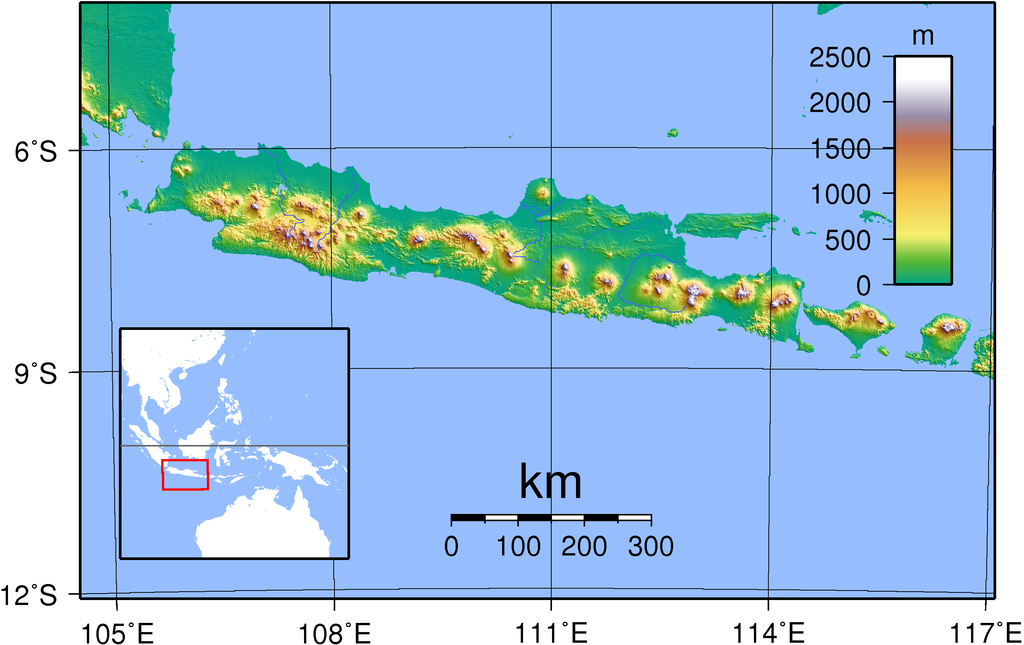
| ဖော်ပြချက် | Topography of Java. Created with GMT from publicly released SRTM data. For locator version, see Image:Java Locator Topography.png |
| ရက်စွဲ | |
| ရင်းမြစ် | ကိုယ်ပိုင်ဖန်တီးမှု |
| စာရေးသူ | Sadalmelik |
လိုင်စင်သတ်မှတ်ခြင်း
| I, the copyright holder of this work, release this work into the public domain. This applies worldwide. In some countries this may not be legally possible; if so: အကျွန်ုပ်သည် ဤဖန်တီးမှုလက်ရာကို ဥပဒေအရလိုအပ်ခြင်းမရှိသည့် မည်သည့်အခြေအနေမျိုးတွက်မဆို၊ မည်သို့သော ရည်ရွယ်ချက်အတွက်မဆို ၎င်းကို မည်သူမဆို အသုံးပြုပိုင်ခွင့်အား ပေးအပ်သည်။ |
ဖိုင်မှတ်တမ်း
ဖိုင်ကို ယင်းနေ့စွဲ အတိုင်း မြင်နိုင်ရန် နေ့စွဲ/အချိန် တစ်ခုခုပေါ်တွင် ကလစ်နှိပ်ပါ။
| နေ့စွဲ/အချိန် | နမူနာပုံငယ် | မှတ်တမ်း ဒိုင်မန်းရှင်းများ | အသုံးပြုသူ | မှတ်ချက် | |
|---|---|---|---|---|---|
| ကာလပေါ် | ၁၈:၄၅၊ ၃၀ ဩဂုတ် ၂၀၀၇ | | ၂၆၈၈ × ၁၆၉၃ (၁.၁၆ MB) | Sadalmelik | {{Information |Description=Topography of Java. Created with GMT from publicly released SRTM data. |Source=self-made |Date=30 Aug, 2007 |Author= Sadalmelik }} Category:Maps of Indonesia Category:Topographic maps of Asia |
ဖိုင်သုံးစွဲမှု
အောက်ပါ စာမျက်နှာ သည် ဤဖိုင်ကို အသုံးပြုထားသည်:
ဂလိုဘယ် ဖိုင်သုံးစွဲမှု
အောက်ပါ အခြားဝီကီများတွင် ဤဖိုင်ကို အသုံးပြုထားသည်-
- ace.wikipedia.org တွင် အသုံးပြုမှု
- af.wikipedia.org တွင် အသုံးပြုမှု
- az.wikipedia.org တွင် အသုံးပြုမှု
- ban.wikipedia.org တွင် အသုံးပြုမှု
- bbc.wikipedia.org တွင် အသုံးပြုမှု
- bg.wikipedia.org တွင် အသုံးပြုမှု
- bg.wikibooks.org တွင် အသုံးပြုမှု
- bjn.wikipedia.org တွင် အသုံးပြုမှု
- bo.wikipedia.org တွင် အသုံးပြုမှု
- cs.wikipedia.org တွင် အသုံးပြုမှု
- de.wikipedia.org တွင် အသုံးပြုမှု
- el.wikipedia.org တွင် အသုံးပြုမှု
- en.wikipedia.org တွင် အသုံးပြုမှု
- en.wiktionary.org တွင် အသုံးပြုမှု
- eo.wikipedia.org တွင် အသုံးပြုမှု
- et.wikipedia.org တွင် အသုံးပြုမှု
- fa.wikipedia.org တွင် အသုံးပြုမှု
- frr.wikipedia.org တွင် အသုံးပြုမှု
- fr.wikipedia.org တွင် အသုံးပြုမှု
- fr.wikinews.org တွင် အသုံးပြုမှု
- gor.wikipedia.org တွင် အသုံးပြုမှု
- hak.wikipedia.org တွင် အသုံးပြုမှု
- ha.wikipedia.org တွင် အသုံးပြုမှု
- he.wikipedia.org တွင် အသုံးပြုမှု
- iba.wikipedia.org တွင် အသုံးပြုမှု
- id.wikipedia.org တွင် အသုံးပြုမှု
- Jawa
- Candi Prambanan
- Bahasa Jawa Tegal
- Bahasa Jawa Banyumasan
- Daftar kabupaten dan kota administrasi di Daerah Khusus Ibukota Jakarta
- Portal:Jawa
- Portal:Jawa/Intro
- Templat:Daftar portal/Indonesia
- Titik ekstrem Jawa
- Bahasa Jawa Indramayu
- Kategori:Sastrawan Jawa
- Garis besar Indonesia
- Kategori:Tokoh ekonomi Jawa
- Kategori:Tokoh seni budaya Jawa
- Kategori:Seniman Jawa
- Bahasa Jawa Pekalongan
- Story:Pulau Jawa
- Daftar kabupaten dan kota administrasi di Daerah Khusus Ibukota Jakarta berdasarkan waktu pembentukan
ဤဖိုင်ကို အခြားနေရာများတွင် အသုံးပြုထားမှုများအား ကြည့်ရှုရန်။