
ဖိုင်:New Zealand location map.svg

Size of this PNG preview of this SVG file: ၄၇၅ × ၅၉၉ ပစ်ဇယ်. အခြား ပုံရိပ်ပြတ်သားမှု: ၁၉၀ × ၂၄၀ ပစ်ဇယ် | ၃၈၀ × ၄၈၀ ပစ်ဇယ် | ၆၀၉ × ၇၆၈ ပစ်ဇယ် | ၈၁၂ × ၁၀၂၄ ပစ်ဇယ် | ၁၆၂၃ × ၂၀၄၈ ပစ်ဇယ် | ၁၉၂၈ × ၂၄၃၂ ပစ်ဇယ်။
မူရင်းဖိုင် (SVG ဖိုင်, ၁၉၂၈ × ၂၄၃၂ pixels ကို အကြံပြုသည်, ဖိုင်အရွယ်အစား - ၂၂၀ KB)
| ဤဖိုင်သည် Wikimedia Commons မှဖြစ်ပြီး အခြားပရောဂျက်များတွင် သုံးကောင်းသုံးလိမ့်မည်။ ယင်း၏ ဖိုင်အကြောင်းစာမျက်နှာ တွင် ဖော်ပြထားချက်ကို အောက်တွင် ပြထားသည်။ Commons သည် မူပိုင်ခွင့်လွတ်လပ်သော မီဒီယာဖိုင်များ သိုလှောင်ထားရာ နေရာ ဖြစ်သည်။ သင်လည်း ပါဝင်ကူညီနိုင်ပါသည်။ |
အကျဉ်းချုပ်
| ဖော်ပြချက် |
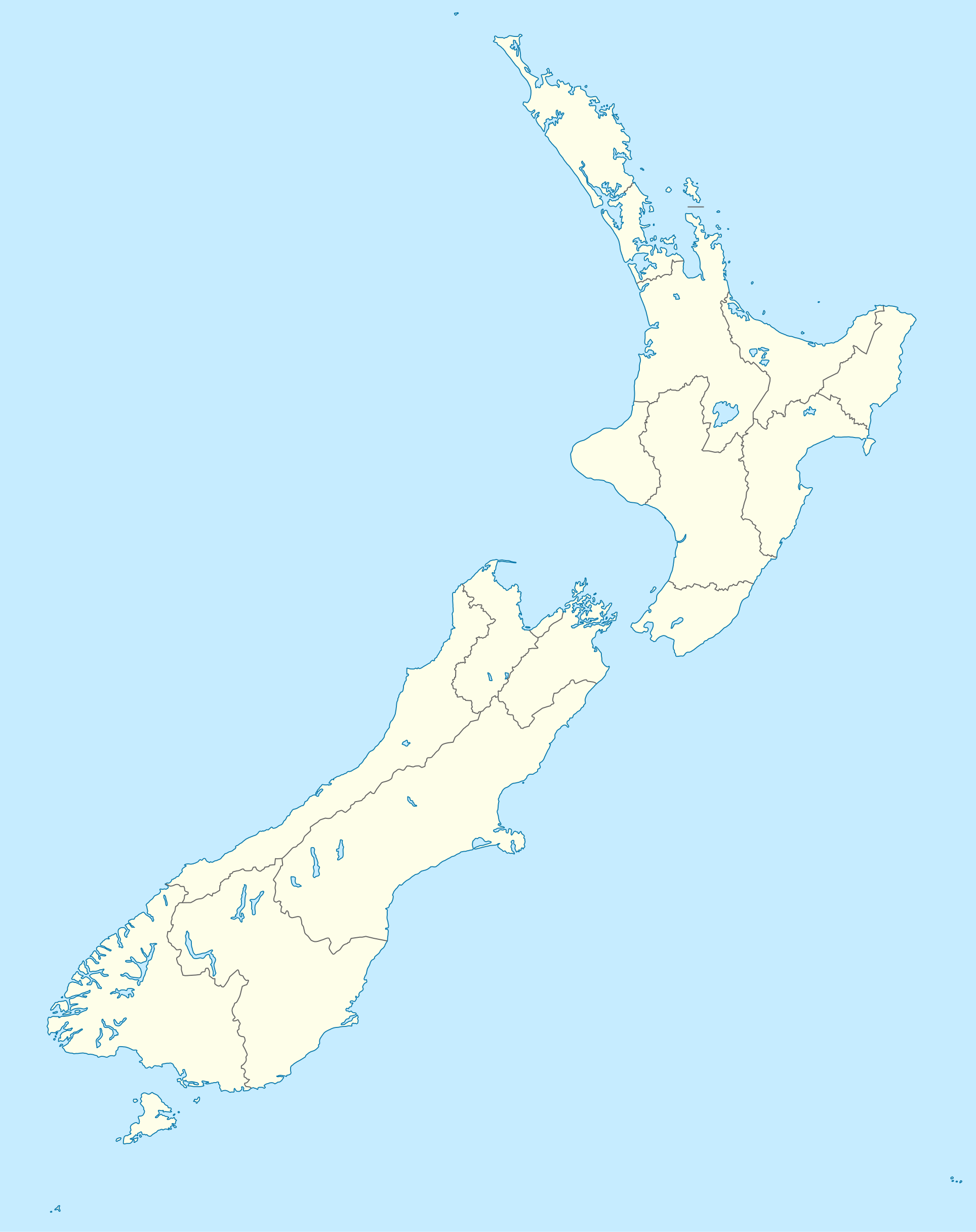
Deutsch: Positionskarte von Neuseeland
Quadratische Plattkarte, N-S-Streckung 120 %. Geographische Begrenzung der Karte:
English: Location map of New Zealand
Equirectangular projection, N/S stretching 120 %. Geographic limits of the map:
Svenska: Plats karta över Nya Zeeland
Equirectangular projektion, N/S sträcker sig 120%. Geografiska gränser för kartan:
|
||
| ရက်စွဲ | |||
| ရင်းမြစ် |
own work, using
|
||
| စာရေးသူ | NordNordWest | ||
| အခြား ဗားရှင်းများ |
Derivative works of this file: |
||
| SVG genesis | ဤ SVG ၏ ကုဒ်သည် ခိုင်လုံသည်။
|

လိုင်စင်သတ်မှတ်ခြင်း
ကျွန်ုပ်၊ ဤလုပ်ဆောင်ချက်၏ မူပိုင်ခွင့်ပိုင်ရှင်အနေဖြင့် ဤနေရာမှ အောက်ပါလိုင်စင်များအောက်တွင် ထုတ်လွှင့်ပါသည်:

|
ဤစာတမ်းကို GNU Free Documentation License, ဗားရှင်း ၁.၂ သို့မဟုတ် Free Software Foundation မှ ဖြန့်ချီထားသော မည်သည့်ယခင်ဗားရှင်းတစ်ခုခုအောက်တွင် Invariant Sections, Front-Cover Texts နှင့် Back-Cover Texts များမပါဝင်ဘဲ ကူးယူခြင်း၊ ဖြန့်ချီခြင်း နှင့်/သို့မဟုတ် ပြင်ဆင်ပြောင်းလဲနိုင်ရန် ခွင့်ပြုသည်။ လိုင်စင်မူပွားကို GNU Free Documentation License ခေါင်းစဉ်အောက်တွင် ထည့်သွင်းထားသည်။ |
ဤဖိုင်ကို Creative Commons Attribution-Share Alike 3.0 Unported လိုင်စင်ဖြင့် သတ်မှတ်ထားသည်။
- သင်သည် လွတ်လပ်စွာ:
- မျှဝေရန် – ဖန်တီးမှုကို ကူးယူရန်၊ ဖြန့်ဖြူးရန်နှင့် ထုတ်လွှင့်ရန်
- ပြန်ရောနှောရန် – ဖန်တီးမှုကို ပြင်ဆင်ညှိနှိုင်းရန်
- အောက်ပါ အခြေအနေများတွင်:
- မှတ်ယူနိုင်ခြင်း – ပြောင်းလဲမှုများ ပြုလုပ်ခဲ့ပါက ဖန်တီးသူ သို့မဟုတ် လိုင်စင်ရှိသူမှ သတ်မှတ်သော အမျိုးအစားကို လိုက်နာရမည် (ဆိုလိုသည်မှာ သင့်အား သို့မဟုတ် သင့်ဖန်တီးမှုတွင် အသုံးပြုခြင်းအား ထောက်ခံချက်ပေးသည်ဟု မဆိုလိုပါ)။
- ထပ်တူမျှဝေ – ဤဖန်တီးမှုအား ပြင်ဆင်ခြင်း၊ ပြောင်းလဲခြင်း သို့မဟုတ် ထပ်ဆင့် ဖန်တီးခြင်း ပြုလုပ်ပါက ရရှိလာသော ဖန်တီးမှုကို ဤဖန်တီးမှုနှင့် သို့မဟုတ် ဆင်တူသော လိုင်စင်ဖြင့်သာ ဖြန့်ချိသင့်သည်။
သင်အလိုရှိရာ လိုင်စင်ကို ရွေးချယ်နိုင်ပါသည်။
ဖိုင်မှတ်တမ်း
ဖိုင်ကို ယင်းနေ့စွဲ အတိုင်း မြင်နိုင်ရန် နေ့စွဲ/အချိန် တစ်ခုခုပေါ်တွင် ကလစ်နှိပ်ပါ။
| နေ့စွဲ/အချိန် | နမူနာပုံငယ် | မှတ်တမ်း ဒိုင်မန်းရှင်းများ | အသုံးပြုသူ | မှတ်ချက် | |
|---|---|---|---|---|---|
| ကာလပေါ် | ၁၆:၀၅၊ ၁၈ ဇူလိုင် ၂၀၂၃ | | ၁၉၂၈ × ၂၄၃၂ (၂၂၀ KB) | NordNordWest | Auckland corr |
| ၁၇:၁၅၊ ၁၃ ဩဂုတ် ၂၀၀၉ |  | ၁၉၂၈ × ၂၄၃၂ (၃၇၆ KB) | NordNordWest | ||
| ၂၀:၂၂၊ ၂ စက်တင်ဘာ ၂၀၀၈ |  | ၁၉၂၈ × ၂၄၃၂ (၃၇၆ KB) | NordNordWest | {{Information |Description= {{de|Positionskarte von Neuseeland}} Quadratische Plattkarte, N-S-Streckung 120 %. Geographische Begrenzung der Karte: * N: 34.0° S * S: 48.3° S * W: 165.8° O * O: 179.4° O {{en|Location map of [[:en:New |
ဖိုင်သုံးစွဲမှု
အောက်ပါ 2 စာမျက်နှာများ သည် ဤဖိုင်ကို အသုံးပြုထားသည်:
ဂလိုဘယ် ဖိုင်သုံးစွဲမှု
အောက်ပါ အခြားဝီကီများတွင် ဤဖိုင်ကို အသုံးပြုထားသည်-
- af.wikipedia.org တွင် အသုံးပြုမှု
- als.wikipedia.org တွင် အသုံးပြုမှု
- an.wikipedia.org တွင် အသုံးပြုမှု
- Plantilla:Mapa de localización Nueva Zelanda
- Auckland
- Queenstown (Nueva Zelanda)
- Arrowtown
- Rotorua
- Wanaka
- Matamata
- Mount Cook Village
- Christchurch
- Cambridge (Nueva Zelanda)
- Lake Tekapo
- Sky Tower (Auckland)
- Nelson (Nueva Zelanda)
- Tarras
- Te Anau
- Geraldine (Nueva Zelanda)
- Cardrona (Nueva Zelanda)
- Puent d'a badía d'Auckland
- Seu d'a Santisma Trinidat d'Auckland
- Seu de Cartón de Christchurch
- Puent penchau d'a foz d'o Kawarau
- Seu de Christchurch
- Seu d'o Santismo Sacramento de Christchurch
- Wellington
- ar.wikipedia.org တွင် အသုံးပြုမှု
ဤဖိုင်ကို အခြားနေရာများတွင် အသုံးပြုထားမှုများအား ကြည့်ရှုရန်။