
ဖိုင်:Planisphæri cœleste.jpg
မူရင်းဖိုင် (၅၈၁၂ × ၃၉၇၂ pixels, ဖိုင်အရွယ်အစား - ၁၉.၀၇ MB, MIME အမျိုးအစား image/jpeg)
| ဤဖိုင်သည် Wikimedia Commons မှဖြစ်ပြီး အခြားပရောဂျက်များတွင် သုံးကောင်းသုံးလိမ့်မည်။ ယင်း၏ ဖိုင်အကြောင်းစာမျက်နှာ တွင် ဖော်ပြထားချက်ကို အောက်တွင် ပြထားသည်။ Commons သည် မူပိုင်ခွင့်လွတ်လပ်သော မီဒီယာဖိုင်များ သိုလှောင်ထားရာ နေရာ ဖြစ်သည်။ သင်လည်း ပါဝင်ကူညီနိုင်ပါသည်။ |
အကျဉ်းချုပ်
| စာရေးသူ |
|
|||||||||||||||||||||||||
| ဖော်ပြချက် |
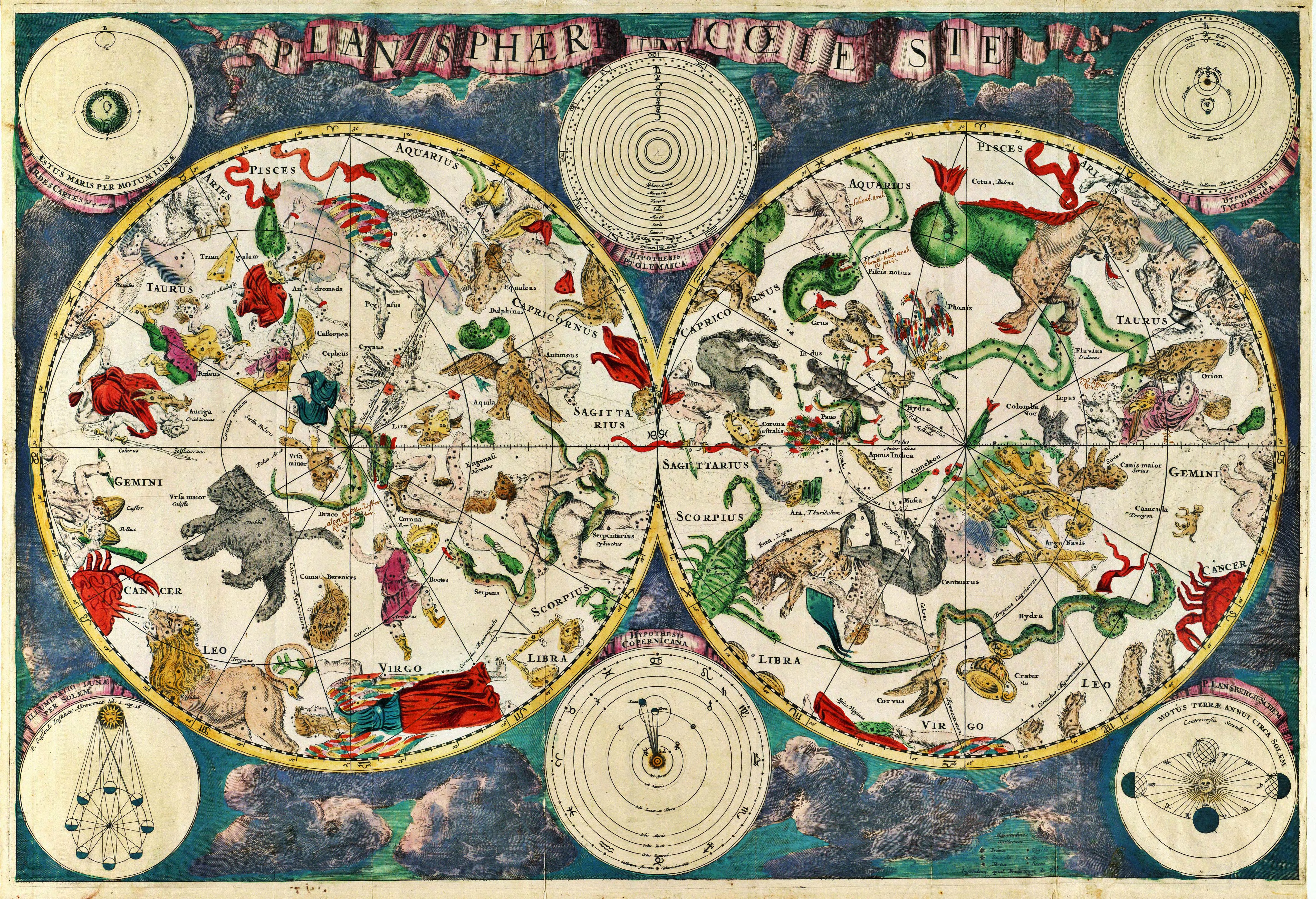
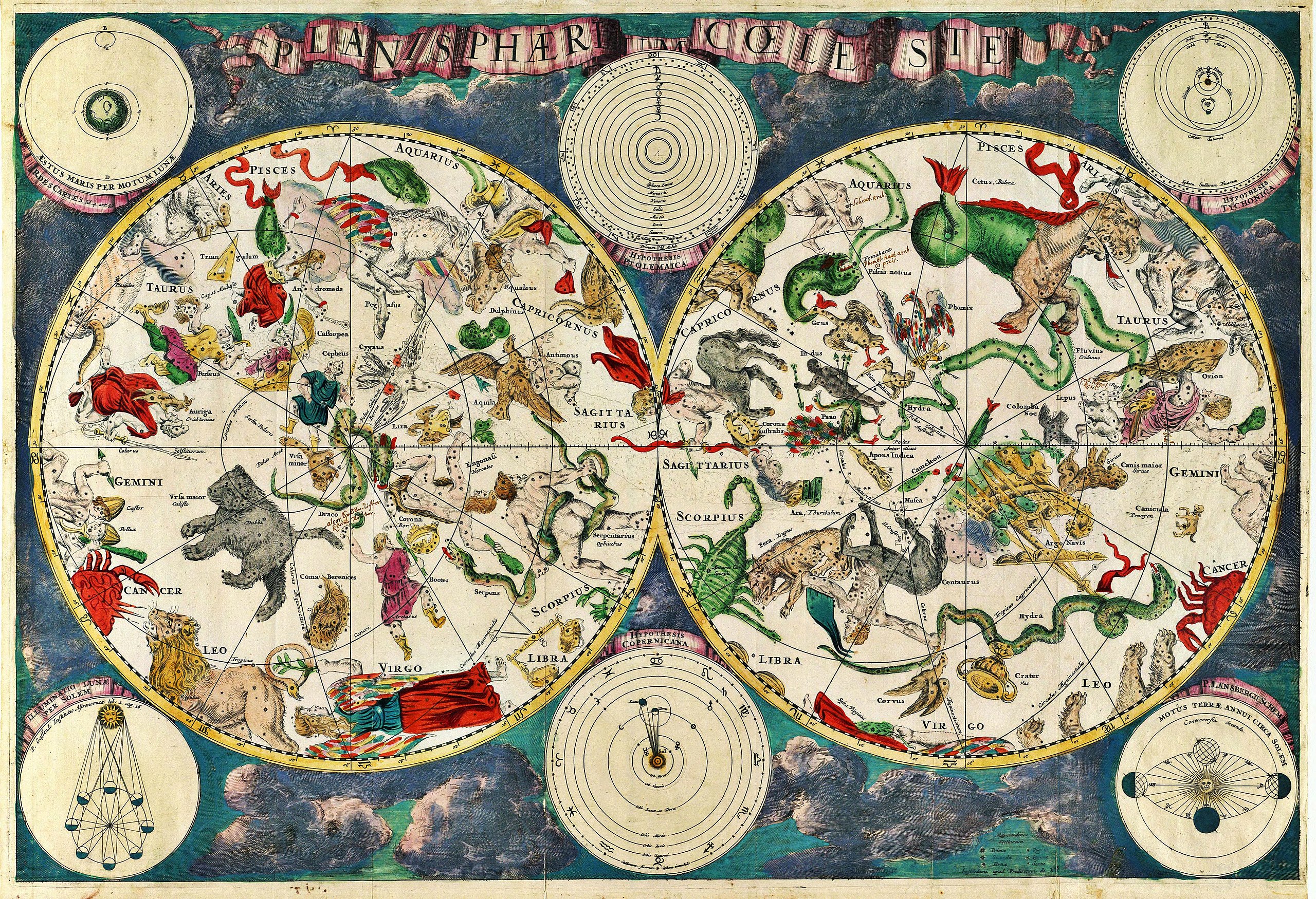
Planisphærium cœleste, denmark, Frederik V English: Celestial map Français : Carte céleste |
|||||||||||||||||||||||||
| ရက်စွဲ | ၁၆၇၀ | |||||||||||||||||||||||||
| ကိုးကားချက်များ | Koninklijke Deense Bibliotheek | |||||||||||||||||||||||||
| Source/Photographer | Transferred from en.wikipedia to Commons. Scanned by Janke | |||||||||||||||||||||||||
မူရင်းတင်ထားသောမှတ်တမ်း
- 2007-03-10 18:20 Janke 1804×1236×8 (3237455 bytes) Celestial map from the 17th century, by the Dutch cartographer Frederik de Wit. Scanned by uploader
လိုင်စင်သတ်မှတ်ခြင်း
|
This is a faithful photographic reproduction of a two-dimensional, public domain work of art. The work of art itself is in the public domain for the following reason:
The official position taken by the Wikimedia Foundation is that "faithful reproductions of two-dimensional public domain works of art are public domain".
This photographic reproduction is therefore also considered to be in the public domain in the United States. In other jurisdictions, re-use of this content may be restricted; see Reuse of PD-Art photographs for details. | ||||
ဖိုင်မှတ်တမ်း
ဖိုင်ကို ယင်းနေ့စွဲ အတိုင်း မြင်နိုင်ရန် နေ့စွဲ/အချိန် တစ်ခုခုပေါ်တွင် ကလစ်နှိပ်ပါ။
| နေ့စွဲ/အချိန် | နမူနာပုံငယ် | မှတ်တမ်း ဒိုင်မန်းရှင်းများ | အသုံးပြုသူ | မှတ်ချက် | |
|---|---|---|---|---|---|
| ကာလပေါ် | ၁၀:၀၁၊ ၂၃ ဒီဇင်ဘာ ၂၀၁၀ | | ၅၈၁၂ × ၃၉၇၂ (၁၉.၀၇ MB) | Joopr | Hogere resolutie |
| ၀၀:၁၈၊ ၂၉ မေ ၂၀၀၇ |  | ၁၈၀၄ × ၁၂၃၆ (၃.၀၉ MB) | STyx | {{Information |Description= {{la}}Planisphæri cœleste {{en}}Celestial map from the 17th century, by the Dutch cartographer Frederik de Wit. {{fr}}Carte céleste du XVII ème siècle, réalisée par le cartographe hollandais Frederik de Wit. {{du}}[http |
ဖိုင်သုံးစွဲမှု
အောက်ပါ 2 စာမျက်နှာများ သည် ဤဖိုင်ကို အသုံးပြုထားသည်:
ဂလိုဘယ် ဖိုင်သုံးစွဲမှု
အောက်ပါ အခြားဝီကီများတွင် ဤဖိုင်ကို အသုံးပြုထားသည်-
- ar.wikipedia.org တွင် အသုံးပြုမှု
- ar.wikibooks.org တွင် အသုံးပြုမှု
- ast.wikipedia.org တွင် အသုံးပြုမှု
- az.wikipedia.org တွင် အသုံးပြုမှု
- ba.wikipedia.org တွင် အသုံးပြုမှု
- bg.wikipedia.org တွင် အသုံးပြုမှု
- bn.wikipedia.org တွင် အသုံးပြုမှု
- ca.wikipedia.org တွင် အသုံးပြုမှု
- cbk-zam.wikipedia.org တွင် အသုံးပြုမှု
- ce.wikipedia.org တွင် အသုံးပြုမှု
- cs.wikipedia.org တွင် အသုံးပြုမှု
- de.wikipedia.org တွင် အသုံးပြုမှု
- el.wikipedia.org တွင် အသုံးပြုမှု
- en.wikipedia.org တွင် အသုံးပြုမှု
- Constellation
- Map
- Natural philosophy
- Star chart
- Wikipedia:Featured picture candidates/March-2007
- Wikipedia:Featured picture candidates/17th century star map
- User:Sj/olpc dictionary images/500
- Portal:Maps/Maps/Historical
- Portal:Maps/Maps/Historical/7
- Talk:Astronomy/Archive 2
- Wikipedia:Wikipedia Signpost/2013-01-14/WikiProject report
- Wikipedia:Wikipedia Signpost/Single/2013-01-14
- en.wikiquote.org တွင် အသုံးပြုမှု
- eo.wikipedia.org တွင် အသုံးပြုမှု
- es.wikipedia.org တွင် အသုံးပြုမှု
- fa.wikipedia.org တွင် အသုံးပြုမှု
- fi.wikipedia.org တွင် အသုံးပြုမှု
- fj.wikipedia.org တွင် အသုံးပြုမှု
- fr.wikipedia.org တွင် အသုံးပြုမှု
- gl.wikipedia.org တွင် အသုံးပြုမှု
ဤဖိုင်ကို အခြားနေရာများတွင် အသုံးပြုထားမှုများအား ကြည့်ရှုရန်။