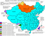
ဖိုင်:ROC Administrative and Claims.png
ပုံပန်းသွင်ပြင်

ဤနမူနာ၏ အရွယ်အစား - ၈၀၀ × ၅၈၄ ပစ်ဇယ်။ အခြား ပုံရိပ်ပြတ်သားမှု: ၃၂၀ × ၂၃၄ ပစ်ဇယ် | ၆၄၀ × ၄၆၇ ပစ်ဇယ် | ၉၂၅ × ၆၇၅ ပစ်ဇယ်။
မူရင်းဖိုင် (၉၂၅ × ၆၇၅ pixels, ဖိုင်အရွယ်အစား - ၁၀၁ KB, MIME အမျိုးအစား image/png)
ဖိုင်မှတ်တမ်း
ဖိုင်ကို ယင်းနေ့စွဲ အတိုင်း မြင်နိုင်ရန် နေ့စွဲ/အချိန် တစ်ခုခုပေါ်တွင် ကလစ်နှိပ်ပါ။
| နေ့စွဲ/အချိန် | နမူနာပုံငယ် | မှတ်တမ်း ဒိုင်မန်းရှင်းများ | အသုံးပြုသူ | မှတ်ချက် | |
|---|---|---|---|---|---|
| ကာလပေါ် | ၁၃:၁၃၊ ၆ နိုဝင်ဘာ ၂၀၁၀ |  | ၉၂၅ × ၆၇၅ (၁၀၁ KB) | Ianbu | {{Information |Description={{en|1=Map of the Republic of China, showing administrative divisions and territorial disputes.}} |Source=File:ROC_Administrative_and_Claims.png |Date=2010-11-06 13:09 (UTC) |Author=Pryaltonian *deriva |
| ၀၄:၅၆၊ ၁၁ စက်တင်ဘာ ၂၀၁၀ |  | ၉၂၅ × ၆၇၅ (၁၁၈ KB) | Spesh531 | finally, a clean version using "Trebuchet MS" Font | |
| ၀၀:၂၇၊ ၁၁ စက်တင်ဘာ ၂၀၁၀ |  | ၈၄၇ × ၆၇၄ (၇၇၃ KB) | Spesh531 | Reverted to version as of 03:05, 10 September 2009 Adds space. Update coming really soon to override .jpg file | |
| ၁၈:၂၃၊ ၁၂ ဩဂုတ် ၂၀၁၀ |  | ၈၄၇ × ၆၇၄ (၈၀၅ KB) | Beao | Transparent. | |
| ၀၃:၀၅၊ ၁၀ စက်တင်ဘာ ၂၀၀၉ |  | ၈၄၇ × ၆၇၄ (၇၇၃ KB) | Ianbu | {{Information |Description={{en|1=Map of the Republic of China, showing administrative divisions and territorial disputes.}}{{zh-hant|中華民國行政區劃及領土糾紛}}{{zh-hans|中华民国行政区划及领土纠纷}} |Source=*[[:File:ROC_Adminis | |
| ၁၉:၄၀၊ ၂၇ စက်တင်ဘာ ၂၀၀၈ |  | ၈၄၇ × ၆၇၄ (၆၈၄ KB) | Pryaltonian~commonswiki | {{Information |Description={{en|1=Map of the Republic of China, showing administrative divisions and territorial disputes.}} |Source=Own work by uploader |Author=Pryaltonian |Date=2008-09-27 |Permission= |other_versions= }} <!--{{Ima |
ဖိုင်သုံးစွဲမှု
အောက်ပါ စာမျက်နှာ သည် ဤဖိုင်ကို အသုံးပြုထားသည်:
ဂလိုဘယ် ဖိုင်သုံးစွဲမှု
အောက်ပါ အခြားဝီကီများတွင် ဤဖိုင်ကို အသုံးပြုထားသည်-
- en.wikipedia.org တွင် အသုံးပြုမှု
- ru.wikipedia.org တွင် အသုံးပြုမှု


