
ဖိုင်:Rs-map.png
သည်ထက်ကြီးသော resolution မရှိပါ.
Rs-map.png (၆၃၄ × ၃၂၃ pixels, ဖိုင်အရွယ်အစား - ၃၇ KB, MIME အမျိုးအစား image/png)
| ဤဖိုင်သည် Wikimedia Commons မှဖြစ်ပြီး အခြားပရောဂျက်များတွင် သုံးကောင်းသုံးလိမ့်မည်။ ယင်း၏ ဖိုင်အကြောင်းစာမျက်နှာ တွင် ဖော်ပြထားချက်ကို အောက်တွင် ပြထားသည်။ Commons သည် မူပိုင်ခွင့်လွတ်လပ်သော မီဒီယာဖိုင်များ သိုလှောင်ထားရာ နေရာ ဖြစ်သည်။ သင်လည်း ပါဝင်ကူညီနိုင်ပါသည်။ |
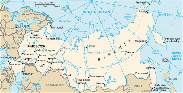
CIA map of Russia. https://www.cia.gov/library/publications/the-world-factbook/geos/rs.html archive copy at the Wayback Machine
This version of CIA World Factbook map has few changes compared to the previous version at Commons.
See also SVG version: Image:Blank map of Russia-geoloc.svg
This image is in the public domain because it contains materials that originally came from the United States Central Intelligence Agency's World Factbook.
|
 |
.jpg)
| Annotations | This image is annotated: View the annotations at Commons |
ဖိုင်မှတ်တမ်း
ဖိုင်ကို ယင်းနေ့စွဲ အတိုင်း မြင်နိုင်ရန် နေ့စွဲ/အချိန် တစ်ခုခုပေါ်တွင် ကလစ်နှိပ်ပါ။
| နေ့စွဲ/အချိန် | နမူနာပုံငယ် | မှတ်တမ်း ဒိုင်မန်းရှင်းများ | အသုံးပြုသူ | မှတ်ချက် | |
|---|---|---|---|---|---|
| ကာလပေါ် | ၁၆:၄၀၊ ၁၆ မေ ၂၀၀၉ | | ၆၃၄ × ၃၂၃ (၃၇ KB) | Pasixxxx | New version of this map from CIA World Factbook site. Few more cities, Yekaterinburg location has changed considerably compared to the Commons' previous version. From CIA World Factbook site [https://www.cia.gov/library/publications/the-world-factbook/geo |
| ၁၅:၅၀၊ ၃ ဒီဇင်ဘာ ၂၀၀၄ |  | ၆၃၅ × ၃၂၄ (၂၉ KB) | Kneiphof | CIA map of Russia, PD |
ဖိုင်သုံးစွဲမှု
အောက်ပါ စာမျက်နှာ သည် ဤဖိုင်ကို အသုံးပြုထားသည်:
ဂလိုဘယ် ဖိုင်သုံးစွဲမှု
အောက်ပါ အခြားဝီကီများတွင် ဤဖိုင်ကို အသုံးပြုထားသည်-
- als.wikipedia.org တွင် အသုံးပြုမှု
- ar.wikipedia.org တွင် အသုံးပြုမှု
- ast.wikipedia.org တွင် အသုံးပြုမှု
- az.wiktionary.org တွင် အသုံးပြုမှု
- ceb.wikipedia.org တွင် အသုံးပြုမှု
- cs.wikipedia.org တွင် အသုံးပြုမှု
- de.wikipedia.org တွင် အသုံးပြုမှု
- diq.wikipedia.org တွင် အသုံးပြုမှု
- dsb.wikipedia.org တွင် အသုံးပြုမှု
- en.wikipedia.org တွင် အသုံးပြုမှု
- Wikipedia:In the news/Candidates/December 2005
- List of twin towns and sister cities in Russia
- Wikipedia:Reference desk/Archives/Science/2007 July 18
- Northern river reversal
- Energy in Russia
- User:Epipelagic/sandbox/ref3
- Module talk:Location map/Archive 1
- User:Andrewjlockley/Hydraulic geoengineering2g
- User:Morriswa/My OCONUS travel
- User:Falcaorib/Russia and Soviet Union
- en.wikibooks.org တွင် အသုံးပြုမှု
- en.wiktionary.org တွင် အသုံးပြုမှု
- es.wikipedia.org တွင် အသုံးပြုမှု
- fr.wikipedia.org တွင် အသုံးပြုမှု
- gl.wikipedia.org တွင် အသုံးပြုမှု
- he.wikipedia.org တွင် အသုံးပြုမှု
- hif.wikipedia.org တွင် အသုံးပြုမှု
- hu.wikipedia.org တွင် အသုံးပြုမှု
- id.wikipedia.org တွင် အသုံးပြုမှု
ဤဖိုင်ကို အခြားနေရာများတွင် အသုံးပြုထားမှုများအား ကြည့်ရှုရန်။