မာတိကာသို့ ခုန်သွားရန်

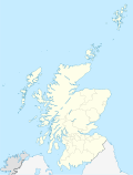
ဖိုင်:Scotland location map.svg

အခြားဘာသာစကားများဖြင့် စာမျက်နှာအကြောင်းအရာများကို ပံ့ပိုးမထားပါ။
This is a file from the Wikimedia Commons
ဝီကီပီးဒီးယား မှ

မူရင်းဖိုင် (SVG ဖိုင်, ၁၁၂၈ × ၁၄၈၃ pixels ကို အကြံပြုသည်, ဖိုင်အရွယ်အစား - ၈၁၀ KB)

အကျဉ်းချုပ်

ဖော်ပြချက်
Deutsch: Positionskarte von Schottland, Vereinigtes Königreich

Quadratische Plattkarte, N-S-Streckung 170 %. Geographische Begrenzung der Karte:

  • N: 61.0° N
  • S: 54.5° N
  • W: 8.8° W
  • O: 0.4° W
English: Location map of Scotland, United Kingdom

Equirectangular projection, N/S stretching 170 %. Geographic limits of the map:

  • N: 61.0° N
  • S: 54.5° N
  • W: 8.8° W
  • E: 0.4° W
ရက်စွဲ ၉ အောက်တိုဘာ ၂၀၀၈ (upload date)
ရင်းမြစ်

own work, using

စာရေးသူ NordNordWest
အခြား ဗားရှင်းများ

Derivative works of this file:

SVG genesis
InfoField
 
SVG ၏ ကုဒ်သည် ခိုင်လုံသည်
 
This map was created with Inkscape.
Kartenwerkstatt
This SVG map has been made or improved in the German Kartenwerkstatt (Map Lab). You can propose maps to improve as well.

လိုင်စင်သတ်မှတ်ခြင်း

ကျွန်ုပ်၊ ဤလုပ်ဆောင်ချက်၏ မူပိုင်ခွင့်ပိုင်ရှင်အနေဖြင့် ဤနေရာမှ အောက်ပါလိုင်စင်များအောက်တွင် ထုတ်လွှင့်ပါသည်:
GNU head ဤစာတမ်းကို GNU Free Documentation License, ဗားရှင်း ၁.၂ သို့မဟုတ် Free Software Foundation မှ ဖြန့်ချီထားသော မည်သည့်ယခင်ဗားရှင်းတစ်ခုခုအောက်တွင် Invariant Sections, Front-Cover Texts နှင့် Back-Cover Texts များမပါဝင်ဘဲ ကူးယူခြင်း၊ ဖြန့်ချီခြင်း နှင့်/သို့မဟုတ် ပြင်ဆင်ပြောင်းလဲနိုင်ရန် ခွင့်ပြုသည်။ လိုင်စင်မူပွားကို GNU Free Documentation License ခေါင်းစဉ်အောက်တွင် ထည့်သွင်းထားသည်။
w:my:Creative Commons
မှတ်ယူနိုင်ခြင်း ထပ်တူမျှဝေ
ဤဖိုင်ကို Creative Commons Attribution-Share Alike 3.0 Unported လိုင်စင်ဖြင့် သတ်မှတ်ထားသည်။
မှတ်ယူနိုင်ခြင်း: Eric Gaba, NordNordWest
သင်သည် လွတ်လပ်စွာ:
  • မျှဝေရန် – ဖန်တီးမှုကို ကူးယူရန်၊ ဖြန့်ဖြူးရန်နှင့် ထုတ်လွှင့်ရန်
  • ပြန်ရောနှောရန် – ဖန်တီးမှုကို ပြင်ဆင်ညှိနှိုင်းရန်
အောက်ပါ အခြေအနေများတွင်:
  • မှတ်ယူနိုင်ခြင်း – ပြောင်းလဲမှုများ ပြုလုပ်ခဲ့ပါက ဖန်တီးသူ သို့မဟုတ် လိုင်စင်ရှိသူမှ သတ်မှတ်သော အမျိုးအစားကို လိုက်နာရမည် (ဆိုလိုသည်မှာ သင့်အား သို့မဟုတ် သင့်ဖန်တီးမှုတွင် အသုံးပြုခြင်းအား ထောက်ခံချက်ပေးသည်ဟု မဆိုလိုပါ)။
  • ထပ်တူမျှဝေ – ဤဖန်တီးမှုအား ပြင်ဆင်ခြင်း၊ ပြောင်းလဲခြင်း သို့မဟုတ် ထပ်ဆင့် ဖန်တီးခြင်း ပြုလုပ်ပါက ရရှိလာသော ဖန်တီးမှုကို ဤဖန်တီးမှုနှင့် သို့မဟုတ် ဆင်တူသော လိုင်စင်ဖြင့်သာ ဖြန့်ချိသင့်သည်။
သင်အလိုရှိရာ လိုင်စင်ကို ရွေးချယ်နိုင်ပါသည်။

ပုံစာများ

ဤဖိုင်၏ဆိုလိုရင်းကို စာတစ်ကြောင်းရှင်းလင်းချက်ဖြင့် ထည့်သွင်းရန်

Items portrayed in this file

depicts အင်္ဂလိပ်

၉ အောက်တိုဘာ 2008

media type အင်္ဂလိပ်

image/svg+xml

data size အင်္ဂလိပ်

၈၂၉၉၁၈ ဘိုက်

height အင်္ဂလိပ်

၁၄၈၃ pixel

width အင်္ဂလိပ်

၁၁၂၈ pixel

checksum အင်္ဂလိပ်

b00fb87e9d2c7ee1b594308fbdd358b646cb58a5

determination method or standard အင်္ဂလိပ်: SHA-1

ဖိုင်မှတ်တမ်း

ဖိုင်ကို ယင်းနေ့စွဲ အတိုင်း မြင်နိုင်ရန် နေ့စွဲ/အချိန် တစ်ခုခုပေါ်တွင် ကလစ်နှိပ်ပါ။

နေ့စွဲ/အချိန်နမူနာပုံငယ်မှတ်တမ်း ဒိုင်မန်းရှင်းများအသုံးပြုသူမှတ်ချက်
ကာလပေါ် ၁၈:၂၇၊ ၉ အောက်တိုဘာ ၂၀၀၈ ၁၈:၂၇၊ ၉ အောက်တိုဘာ ၂၀၀၈ ရက်က မူအတွက် နမူနာပုံငယ်၁၁၂၈ × ၁၄၈၃ (၈၁၀ KB)NordNordWest{{Information |Description= {{de|Positionskarte von Schottland, Vereinigtes Königreich}} Quadratische Plattkarte, N-S-Streckung 170 %. Geographische Begrenzung der Karte: * N: 61.0° N * S: 54.5° N * W:

အောက်ပါ 2 စာမျက်နှာများ သည် ဤဖိုင်ကို အသုံးပြုထားသည်:

ဂလိုဘယ် ဖိုင်သုံးစွဲမှု

အောက်ပါ အခြားဝီကီများတွင် ဤဖိုင်ကို အသုံးပြုထားသည်-

ဤဖိုင်ကို အခြားနေရာများတွင် အသုံးပြုထားမှုများအား ကြည့်ရှုရန်။

မီတာဒေတာ