
ဖိုင်:Vegetation.png

ဤနမူနာ၏ အရွယ်အစား - ၈၀၀ × ၃၅၉ ပစ်ဇယ်။ အခြား ပုံရိပ်ပြတ်သားမှု: ၃၂၀ × ၁၄၄ ပစ်ဇယ် | ၆၄၀ × ၂၈၇ ပစ်ဇယ် | ၁၃၈၅ × ၆၂၂ ပစ်ဇယ်။
မူရင်းဖိုင် (၁၃၈၅ × ၆၂၂ pixels, ဖိုင်အရွယ်အစား - ၈၅ KB, MIME အမျိုးအစား image/png)
| ဤဖိုင်သည် Wikimedia Commons မှဖြစ်ပြီး အခြားပရောဂျက်များတွင် သုံးကောင်းသုံးလိမ့်မည်။ ယင်း၏ ဖိုင်အကြောင်းစာမျက်နှာ တွင် ဖော်ပြထားချက်ကို အောက်တွင် ပြထားသည်။ Commons သည် မူပိုင်ခွင့်လွတ်လပ်သော မီဒီယာဖိုင်များ သိုလှောင်ထားရာ နေရာ ဖြစ်သည်။ သင်လည်း ပါဝင်ကူညီနိုင်ပါသည်။ |

|
This map image could be re-created using vector graphics as an SVG file. This has several advantages; see Commons:Media for cleanup for more information. If an SVG form of this image is available, please upload it and afterwards replace this template with
{{vector version available|new image name}}.
It is recommended to name the SVG file “Vegetation.svg”—then the template Vector version available (or Vva) does not need the new image name parameter. |
Any autoconfirmed user can overwrite this file from the same source. Please ensure that overwrites comply with the guideline.
အကျဉ်းချုပ်
| ဖော်ပြချက် |
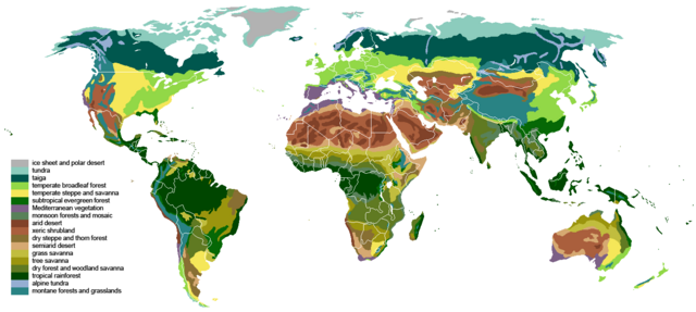
English: The main biomes in the world. Drawn by hand using maps.
Ice sheet and polar desert
Tundra
Taiga
Temperate broadleaf and mixed forest
Temperate steppe
Subtropical moist forest
Mediterranean vegetation
Tropical and subtropical moist broadleaf forests
Arid desert
Xeric shrubland
Dry steppe
Semiarid desert
Grass savanna
Tree savanna
Tropical and subtropical dry forest
Tropical rainforest
Alpine tundra
Montane forest Italiano: I principali biomi nel mondo.
Coltre di ghiaccio e deserto polare
Tundra artica
Taiga
Foresta temperata di latifoglie e mista
Steppa temperata
Foresta umida subtropicale
Vegetazione Mediterranea
Foresta umida di latifoglie tropicale e subtropicale
Deserto arido
Deserto e macchia xerofila
Steppa arida
Deserto semiarido
Savana erbosa
Savana arborea
Foresta monsonica
Foresta pluviale tropicale
Tundra alpina
Foresta montana Español: The main biomes in the world.
Capa de hielo y desierto polar
Tundra
Taiga
Bosques templados de frondosas y mixtos
Estepa templada
Bosques humedos subtropical
Vegetación mediterranea
Bosque húmedo tropical y subtropical de frondosas
Desierto árido
Matorral xerófilo
Estepa seca
Desierto semiárido
Sabana de hierba
Tree savanna
Bosque seco tropical
Selva tropical
Pradera alpina
Bosque de montaña 中文:世界陆地自然区域分布。
冰盖及极地荒漠
苔原
针叶林
温带阔叶林
温带草原
亚热带雨林
地中海硬叶林
季雨林
沙漠
近沙漠
干旱草原
半干旱沙漠
稀树草原
多树草原
亚热带干燥林
热带雨林
高山苔原
山地森林 Polski: Główne biomy występujące na Ziemi.
pokrywy lodowe i pustynie polarne
tundra
tajga
las liściasty strefy umiarkowanej
stepy
podzwrotnikowy las tropikalny
roślinność śródziemnomorska
lasy monsunowe
pustynie jałowe
sucha roślinność
suche stepy
pustynie półsuche
sawanna trawiasta
sawanna drzewiasta
las podzwrotnikowy suchy
lasy tropikalne
tundra alpejska
lasy górskie Français : Les principaux biomes du monde.
Inlandsis et déserts polaires
Toundra
Taïga
Forêts feuillues caducifoliées tempérées
Prairies
Forêts sempervirentes subtropicales
Forêts sempervirentes méditerranéennes
Forêts de mousson
Déserts arides
Déserts et broussailles xérophytes
Steppe aride
Déserts semi-arides
Savanes
Savanes et forêts claires
Forêts tropicales caducifoliées
Forêts sempervirentes tropicales
Toundra alpine
Forêts de montagne Русский: Карта распределения основных биомов суши.
Арктическая пустыня
Тундра
Тайга
Смешанный лес
Лесостепь
Субтропический лес
Жестколистные вечнозеленые леса и кустарники
Муссонный лес
Засушливая пустыня
Полупустыня
Засушливая степь
Полузасушливая пустыня
Травянистая саванна
Древесная саванна
Сухие тропические леса
Влажные тропические леса
Альпийская тундра
Горный лес Українська: Основні біоми Землі.
Льодовики та Полярні пустелі
Тундра
Тайга
Листопадні ліси помірного клімату
Степи
Субтропічні дощові ліси
Чапараль
Мусонні ліси
Пустелі
Скреб
Сухі степи
Напівпустелі
Савани
Лісостеп
Субтропічний сухий ліс
Тропічний дощовий ліс
Альпійські луки
Гірські криволісся |
| ရက်စွဲ | |
| ရင်းမြစ် |
The blank world map in Commons and WSOY Iso karttakirja for the information. Referred to over a hundred sources, but here are some of the more extensively used ones: [1], [2], [3], [4], [5], [6], [7], [8], [9], [10] |
| စာရေးသူ | Ville Koistinen (user Vzb83) |
| အခြား ဗားရှင်းများ |
Derivative works of this file: |
![[5]](https://www.surfaceview.co.uk/storage/image/VMA0018.jpg)
![[6]](https://upload.wikimedia.org/wikipedia/commons/4/4f/Vegetationszonen.png)
![[7]](https://esdac.jrc.ec.europa.eu/images/Eudasm/Africa/images/maps/download/afr_veg.jpg)
![[8]](https://www.researchgate.net/profile/Julie-Morin-9/publication/319979374/figure/fig2/AS:614404802478081@1523496928789/UNESCO-AETFAT-UNSO-Whites-vegetation-map-of-Africa-The-Guineo-Congolian-regional.png)
![[9]](https://www.researchgate.net/profile/Andrea-Kay/publication/276452894/figure/fig1/AS:623557285523457@1525679050775/Map-of-study-area-showing-modern-potential-natural-vegetation-simplified-from-White.png)
![[10]](https://i.pinimg.com/originals/5d/b3/b5/5db3b5b71e47b5467d8df815cd525df5.png)
|
|
This biogeographical map image could be re-created using vector graphics as an SVG file. This has several advantages; see Commons:Media for cleanup for more information. If an SVG form of this image is available, please upload it and afterwards replace this template with
{{vector version available|new image name}}.
It is recommended to name the SVG file “Vegetation.svg”—then the template Vector version available (or Vva) does not need the new image name parameter. |
လိုင်စင်သတ်မှတ်ခြင်း
ကျွန်ုပ်၊ ဤလုပ်ဆောင်ချက်၏ မူပိုင်ခွင့်ပိုင်ရှင်အနေဖြင့် ဤနေရာမှ အောက်ပါလိုင်စင်များအောက်တွင် ထုတ်လွှင့်ပါသည်:

|
ဤစာတမ်းကို GNU Free Documentation License, ဗားရှင်း ၁.၂ သို့မဟုတ် Free Software Foundation မှ ဖြန့်ချီထားသော မည်သည့်ယခင်ဗားရှင်းတစ်ခုခုအောက်တွင် Invariant Sections, Front-Cover Texts နှင့် Back-Cover Texts များမပါဝင်ဘဲ ကူးယူခြင်း၊ ဖြန့်ချီခြင်း နှင့်/သို့မဟုတ် ပြင်ဆင်ပြောင်းလဲနိုင်ရန် ခွင့်ပြုသည်။ လိုင်စင်မူပွားကို GNU Free Documentation License ခေါင်းစဉ်အောက်တွင် ထည့်သွင်းထားသည်။ |
| ဤဖိုင်ကို Creative Commons Attribution-Share Alike 3.0 Unported လိုင်စင်ဖြင့် သတ်မှတ်ထားသည်။ | ||
| ||
| This licensing tag was added to this file as part of the GFDL licensing update. |
ဤဖိုင်သည် Creative Commons Attribution-Share Alike 2.5 Generic, 2.0 Generic and 1.0 Generic လိုင်စင်အောက်တွင် လိုင်စင်သတ်မှတ်ထားပါသည်။
- သင်သည် လွတ်လပ်စွာ:
- မျှဝေရန် – ဖန်တီးမှုကို ကူးယူရန်၊ ဖြန့်ဖြူးရန်နှင့် ထုတ်လွှင့်ရန်
- ပြန်ရောနှောရန် – ဖန်တီးမှုကို ပြင်ဆင်ညှိနှိုင်းရန်
- အောက်ပါ အခြေအနေများတွင်:
- မှတ်ယူနိုင်ခြင်း – ပြောင်းလဲမှုများ ပြုလုပ်ခဲ့ပါက ဖန်တီးသူ သို့မဟုတ် လိုင်စင်ရှိသူမှ သတ်မှတ်သော အမျိုးအစားကို လိုက်နာရမည် (ဆိုလိုသည်မှာ သင့်အား သို့မဟုတ် သင့်ဖန်တီးမှုတွင် အသုံးပြုခြင်းအား ထောက်ခံချက်ပေးသည်ဟု မဆိုလိုပါ)။
- ထပ်တူမျှဝေ – ဤဖန်တီးမှုအား ပြင်ဆင်ခြင်း၊ ပြောင်းလဲခြင်း သို့မဟုတ် ထပ်ဆင့် ဖန်တီးခြင်း ပြုလုပ်ပါက ရရှိလာသော ဖန်တီးမှုကို ဤဖန်တီးမှုနှင့် သို့မဟုတ် ဆင်တူသော လိုင်စင်ဖြင့်သာ ဖြန့်ချိသင့်သည်။
သင်အလိုရှိရာ လိုင်စင်ကို ရွေးချယ်နိုင်ပါသည်။
ဖိုင်မှတ်တမ်း
ဖိုင်ကို ယင်းနေ့စွဲ အတိုင်း မြင်နိုင်ရန် နေ့စွဲ/အချိန် တစ်ခုခုပေါ်တွင် ကလစ်နှိပ်ပါ။
| နေ့စွဲ/အချိန် | နမူနာပုံငယ် | မှတ်တမ်း ဒိုင်မန်းရှင်းများ | အသုံးပြုသူ | မှတ်ချက် | |
|---|---|---|---|---|---|
| ကာလပေါ် | ၁၈:၅၅၊ ၂၄ မတ် ၂၀၂၄ | | ၁၃၈၅ × ၆၂၂ (၈၅ KB) | Berkserker | Added more level of detail, particularly to montane and arid regions. Corrections to savannas. |
| ၂၁:၄၄၊ ၁၈ စက်တင်ဘာ ၂၀၂၃ |  | ၁၃၈၅ × ၆၂၂ (၈၁ KB) | Berkserker | Minor correction to key | |
| ၂၁:၀၁၊ ၁၈ စက်တင်ဘာ ၂၀၂၃ |  | ၁၃၈၅ × ၆၂၂ (၈၀ KB) | Berkserker | Slight correction to Eastern Australia | |
| ၀၉:၃၇၊ ၁၁ ဩဂုတ် ၂၀၂၀ |  | ၁၃၈၅ × ၆၂၂ (၈၀ KB) | Berkserker | Corrections to Madagascar | |
| ၁၈:၃၅၊ ၆ ဩဂုတ် ၂၀၂၀ |  | ၁၃၈၅ × ၆၂၂ (၈၀ KB) | Berkserker | Minor optimization according to Dyer 2006 | |
| ၀၇:၀၁၊ ၅ ဩဂုတ် ၂၀၂၀ |  | ၁၃၈၅ × ၆၂၂ (၈၀ KB) | Berkserker | Added a third source: Dyer 2006, specifically to address the issues in Eastern USA | |
| ၀၃:၄၀၊ ၁၅ ဇွန် ၂၀၂၀ |  | ၁၃၈၅ × ၆၂၂ (၈၀ KB) | Berkserker | More corrections as well as fixing remaining dead pixels | |
| ၁၃:၂၂၊ ၉ ဇွန် ၂၀၂၀ |  | ၁၃၈၅ × ၆၂၂ (၈၀ KB) | Berkserker | Further corrections based on the same sources | |
| ၀၇:၂၀၊ ၂၁ မတ် ၂၀၂၀ |  | ၁၃၈၅ × ၆၂၂ (၈၀ KB) | Berkserker | Minor correction to Andean montane forests | |
| ၀၇:၀၉၊ ၂၁ မတ် ၂၀၂၀ |  | ၁၃၈၅ × ၆၂၂ (၈၀ KB) | Berkserker | Fixed key and map colors not matching |
ဖိုင်သုံးစွဲမှု
ဤဖိုင်ကို အသုံးပြုထားသော စာမျက်နှာများမရှိပါ။
ဂလိုဘယ် ဖိုင်သုံးစွဲမှု
အောက်ပါ အခြားဝီကီများတွင် ဤဖိုင်ကို အသုံးပြုထားသည်-
- bh.wikipedia.org တွင် အသုံးပြုမှု
- bn.wikipedia.org တွင် အသုံးပြုမှု
- bs.wikipedia.org တွင် အသုံးပြုမှု
- ckb.wikipedia.org တွင် အသုံးပြုမှု
- cs.wikipedia.org တွင် အသုံးပြုမှု
- cv.wikipedia.org တွင် အသုံးပြုမှု
- el.wikipedia.org တွင် အသုံးပြုမှု
- en.wikipedia.org တွင် အသုံးပြုမှု
- en.wikibooks.org တွင် အသုံးပြုမှု
- et.wikipedia.org တွင် အသုံးပြုမှု
- eu.wikipedia.org တွင် အသုံးပြုမှု
- fa.wikipedia.org တွင် အသုံးပြုမှု
- fr.wikipedia.org တွင် အသုံးပြုမှု
- hi.wikibooks.org တွင် အသုံးပြုမှု
- id.wikipedia.org တွင် အသုံးပြုမှု
- ik.wikipedia.org တွင် အသုံးပြုမှု
- ku.wikipedia.org တွင် အသုံးပြုမှု
- mk.wikipedia.org တွင် အသုံးပြုမှု
- mt.wikipedia.org တွင် အသုံးပြုမှု
- no.wikipedia.org တွင် အသုံးပြုမှု
- oc.wikipedia.org တွင် အသုံးပြုမှု
- om.wikipedia.org တွင် အသုံးပြုမှု
- pnb.wikipedia.org တွင် အသုံးပြုမှု
- ps.wikipedia.org တွင် အသုံးပြုမှု
- pt.wikipedia.org တွင် အသုံးပြုမှု
- si.wikipedia.org တွင် အသုံးပြုမှု
- sl.wikipedia.org တွင် အသုံးပြုမှု
- sq.wikipedia.org တွင် အသုံးပြုမှု
- ta.wikipedia.org တွင် အသုံးပြုမှု
- th.wikipedia.org တွင် အသုံးပြုမှု
- tr.wikipedia.org တွင် အသုံးပြုမှု
- ur.wikipedia.org တွင် အသုံးပြုမှု
- vi.wikipedia.org တွင် အသုံးပြုမှု
ဤဖိုင်ကို အခြားနေရာများတွင် အသုံးပြုထားမှုများအား ကြည့်ရှုရန်။