
ဖိုင်:World Time Zones Map.png

ဤနမူနာ၏ အရွယ်အစား - ၈၀၀ × ၄၃၁ ပစ်ဇယ်။ အခြား ပုံရိပ်ပြတ်သားမှု: ၃၂၀ × ၁၇၃ ပစ်ဇယ် | ၆၄၀ × ၃၄၅ ပစ်ဇယ် | ၁၀၂၄ × ၅၅၂ ပစ်ဇယ် | ၁၂၈၀ × ၆၉၀ ပစ်ဇယ် | ၂၅၆၀ × ၁၃၈၀ ပစ်ဇယ် | ၄၀၀၀ × ၂၁၅၇ ပစ်ဇယ်။
မူရင်းဖိုင် (၄၀၀၀ × ၂၁၅၇ pixels, ဖိုင်အရွယ်အစား - ၂.၉၄ MB, MIME အမျိုးအစား image/png)
| ဤဖိုင်သည် Wikimedia Commons မှဖြစ်ပြီး အခြားပရောဂျက်များတွင် သုံးကောင်းသုံးလိမ့်မည်။ ယင်း၏ ဖိုင်အကြောင်းစာမျက်နှာ တွင် ဖော်ပြထားချက်ကို အောက်တွင် ပြထားသည်။ Commons သည် မူပိုင်ခွင့်လွတ်လပ်သော မီဒီယာဖိုင်များ သိုလှောင်ထားရာ နေရာ ဖြစ်သည်။ သင်လည်း ပါဝင်ကူညီနိုင်ပါသည်။ |
အကျဉ်းချုပ်

|
File:World Time Zones Map.svg is a vector version of this file. It should be used in place of this PNG file when not inferior.
File:World Time Zones Map.png → File:World Time Zones Map.svg
For more information, see Help:SVG. |
 |
| ဖော်ပြချက် |
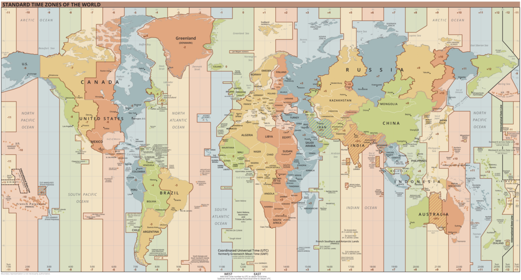
Español: Mapa de los husos horarios vigentes.
English: Map of current de facto time zones.
Українська: Мапа часових поясів.
Français : Carte des fuseaux horaires en cours.
Deutsch: Karte der aktuellen de facto Zeitzonen.
Português: Mapa dos fusos horários atuais.
Italiano: Mappa degli attuali fusi orari.
中文:目前的时区地图。
中文(臺灣):現在的時區地圖。
日本語: 現在のタイムゾーンの地図。
Русский: Карта текущих часовых поясов.
Bahasa Indonesia: Peta zona waktu di dunia.
العربية: خريطة المناطق الزمنية الحالية۔
اردو: موجودہ مناطقِ وقت کا نقشہ۔
فارسی: نقشه مناطق زمانی فعلی۔ |
| ရက်စွဲ | |
| ရင်းမြစ် |
Outline based on the map by the U.S. Central Intelligence Agency (CIA). |
| စာရေးသူ | UnaitxuGV, Heitordp and others |
| အခြား ဗားရှင်းများ |
|
- ↑ Abkhazia and South Ossetia switched to winter time together with Russia, Caucasian Knot, 26 October 2014 (in Russian).
- ↑ New Russian regions to switch to Moscow time – Industry and Trade Ministry, TASS Russian News Agency, 27 January 2023.
- ↑ New regions' move to Moscow time zone 'symbolic' – Kremlin, TASS Russian News Agency, 17 April 2023.
လိုင်စင်သတ်မှတ်ခြင်း
This work is in the public domain in the United States because it is a work prepared by an officer or employee of the United States Government as part of that person’s official duties under the terms of Title 17, Chapter 1, Section 105 of the US Code.
Note: This only applies to original works of the Federal Government and not to the work of any individual U.S. state, territory, commonwealth, county, municipality, or any other subdivision. This template also does not apply to postage stamp designs published by the United States Postal Service since 1978. (See § 313.6(C)(1) of Compendium of U.S. Copyright Office Practices). It also does not apply to certain US coins; see The US Mint Terms of Use.
|
 | |
| This file has been identified as being free of known restrictions under copyright law, including all related and neighboring rights. | ||
ဖိုင်မှတ်တမ်း
ဖိုင်ကို ယင်းနေ့စွဲ အတိုင်း မြင်နိုင်ရန် နေ့စွဲ/အချိန် တစ်ခုခုပေါ်တွင် ကလစ်နှိပ်ပါ။
| နေ့စွဲ/အချိန် | နမူနာပုံငယ် | မှတ်တမ်း ဒိုင်မန်းရှင်းများ | အသုံးပြုသူ | မှတ်ချက် | |
|---|---|---|---|---|---|
| ကာလပေါ် | ၀၀:၃၁၊ ၂၄ မတ် ၂၀၂၅ | | ၄၀၀၀ × ၂၁၅၇ (၂.၉၄ MB) | Heitordp | Updated Chile |
| ၁၂:၅၄၊ ၂၆ နိုဝင်ဘာ ၂၀၂၄ |  | ၄၀၀၀ × ၂၁၅၇ (၂.၉၄ MB) | Heitordp | Adjusted Ukraine and Georgia per discussion here | |
| ၀၆:၂၁၊ ၁၅ အောက်တိုဘာ ၂၀၂၄ |  | ၄၀၀၀ × ၂၁၅၇ (၂.၉၄ MB) | Heitordp | Updated Paraguay, adjusted Micronesia | |
| ၀၅:၄၄၊ ၃၁ မတ် ၂၀၂၄ |  | ၄၀၀၀ × ၂၁၅၇ (၂.၉၄ MB) | Heitordp | Updated Greenland, adjusted Vietnam | |
| ၂၁:၃၁၊ ၂၉ ဖေဖော်ဝါရီ ၂၀၂၄ |  | ၄၀၀၀ × ၂၁၅၇ (၂.၉၄ MB) | Heitordp | Updated Kazakhstan | |
| ၀၅:၂၃၊ ၃ ဇန်နဝါရီ ၂၀၂၄ |  | ၄၀၀၀ × ၂၁၅၇ (၂.၉၅ MB) | Heitordp | Removed note about Kuril Islands, adjusted time zone boundary in Nunavut, changed cities in North America | |
| ၀၂:၁၄၊ ၂၆ စက်တင်ဘာ ၂၀၂၃ |  | ၄၀၀၀ × ၂၁၅၇ (၂.၉၆ MB) | Heitordp | Updated Eswatini | |
| ၀၈:၃၆၊ ၂၃ ဧပြီ ၂၀၂၃ |  | ၄၀၀၀ × ၂၁၅၇ (၂.၉၆ MB) | Heitordp | Adjusted Australia, Ukraine, Spain, Cape Town, Syria, Jordan, Karachi, Omsk, Ürümqi, Petropavlovsk-Kamchatsky | |
| ၂၁:၅၃၊ ၅ ဧပြီ ၂၀၂၃ |  | ၄၀၀၀ × ၂၁၅၇ (၂.၉၆ MB) | Heitordp | Updated most of Greenland, law specifies UTC–2 with no DST in 2023 | |
| ၂၁:၅၈၊ ၂၇ မတ် ၂၀၂၃ |  | ၄၀၀၀ × ၂၁၅၇ (၂.၉၆ MB) | Heitordp | Added names of British Crown dependencies and Mayotte; adjusted Rockall and names of Brazilian islands |
ဖိုင်သုံးစွဲမှု
အောက်ပါ 5 စာမျက်နှာများ သည် ဤဖိုင်ကို အသုံးပြုထားသည်:
ဂလိုဘယ် ဖိုင်သုံးစွဲမှု
အောက်ပါ အခြားဝီကီများတွင် ဤဖိုင်ကို အသုံးပြုထားသည်-
- ab.wikipedia.org တွင် အသုံးပြုမှု
- af.wikipedia.org တွင် အသုံးပြုမှု
- als.wikipedia.org တွင် အသုံးပြုမှု
- alt.wikipedia.org တွင် အသုံးပြုမှု
- am.wikipedia.org တွင် အသုံးပြုမှု
- an.wikipedia.org တွင် အသုံးပြုမှု
- ar.wikipedia.org တွင် အသုံးပြုမှု
- ary.wikipedia.org တွင် အသုံးပြုမှု
- arz.wikipedia.org တွင် အသုံးပြုမှု
- ast.wikipedia.org တွင် အသုံးပြုမှု
- as.wikipedia.org တွင် အသုံးပြုမှု
- av.wikipedia.org တွင် အသုံးပြုမှု
- azb.wikipedia.org တွင် အသုံးပြုမှု
- ban.wikipedia.org တွင် အသုံးပြုမှု
- bat-smg.wikipedia.org တွင် အသုံးပြုမှု
- bcl.wikipedia.org တွင် အသုံးပြုမှု
- be-tarask.wikipedia.org တွင် အသုံးပြုမှု
- be.wikipedia.org တွင် အသုံးပြုမှု
- bg.wikipedia.org တွင် အသုံးပြုမှု
- bh.wikipedia.org တွင် အသုံးပြုမှု
- bjn.wikipedia.org တွင် အသုံးပြုမှု
- blk.wikipedia.org တွင် အသုံးပြုမှု
- bn.wikipedia.org တွင် အသုံးပြုမှု
ဤဖိုင်ကို အခြားနေရာများတွင် အသုံးပြုထားမှုများအား ကြည့်ရှုရန်။